

Even if you slept through history class, there is something mysterious and timeless about petroglyphs – puzzling over the messages, events, and culture communicated to us from ancient peoples and civilizations.
While much has been lost on the Silk Road, in the harsh passage of time, these drawings have survived endless trials for thousands of years, giving us a glimpse into a life long since passed.
It may look dull in history books, but it certainly isn’t when you’re in the middle of the snowcapped mountains exploring sites with the aid of an experienced travel guide from Kyrgyzstan who can also fill you in on local stories and legends.
Petroglyph Meaning
One of the signs of early habitation in the area are petroglyphs, (the word “petroglyph” comes from the Greek: petra meaning “stone” and glyphe meaning “to draw”), and many such rock drawings have been discovered in Kyrgyzstan dating back to several centuries BC.
These drawings, left for us on high rocks and in deep caves provide evidence of the way of life and the environment of prehistory when there was no system of writing
Rock drawings appear to have been made in two ancient artistic styles.
- The first technique was silhouette or shadow, typical of many ancient pictures. Blows were made with a metallic or stone instrument to take out the entire surface of the rock nearly 2 mm deep inside the silhouette. Some pictures were beaten by blunt tools which removed only a thin sun burnt rock layer, and this is typical of later periods.
- Another technique used tools with sharp edges and frequent blows with these produced a deep line engraved in the rock.
x
Osh Province
Museum Sailamon Too
The original caves of Suleiman Mountain have been extended and lined with gunnite and illuminated with chandeliers and museum provides a history of the people living in Kyrgyzstan over the centuries including the history of the Zooastrians who lived here from the third century BCE.
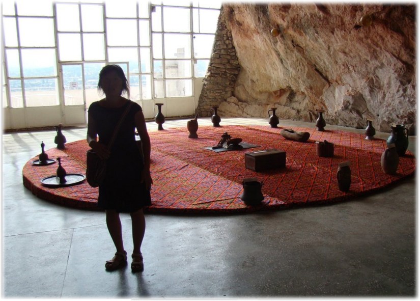
There is plenty of petrogrophs scratched into the rock face. There are more than 100 specimens within the caves including depictions of people, animals, and solar symbols.
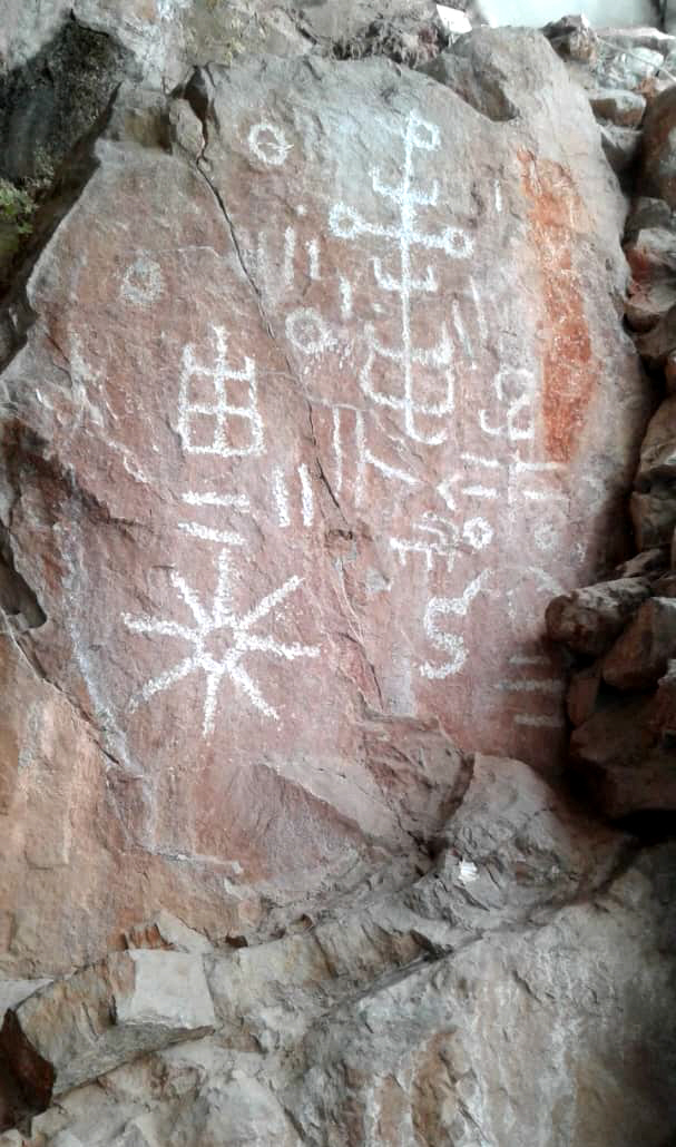
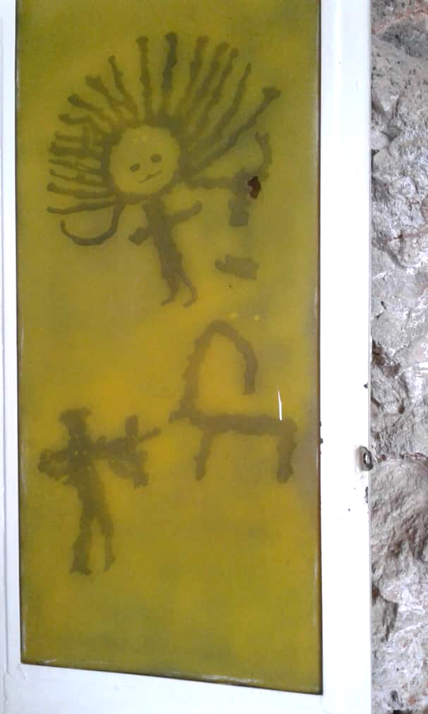
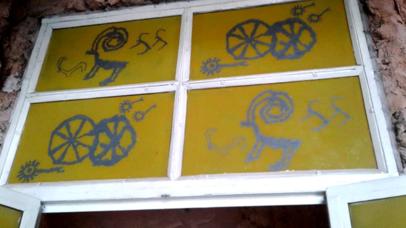
Among the oldest paintings are animals such as the Argali (Marco Polo sheep), horses, camels, reindeer, bulls, wolves, dogs, wild boars and birds – whilst others depict hunting scenes. It is probably incorrect to think that ancient people only depicted the animals that they hunted, and many scholars suggest that the rock drawings depict mythological images with symbols representing the sun and moon and other entities. Most interesting are some etchings that appear to depict scenes of fire worship and some unidentifiable signs resembling modern day airplanes and rail way tracks.
When did we start believing in God? Could these petroglyphs tell us?


Today, we use emojis to say some of the same things.
All signage is in Kyrgyz and Russian, so you need to get an English speaking guide to take you around.


x
Museum Saleimto Too History
The museum tells the story of the local people from prehistory through the epic of the Silk Road to modern times It would not have been fun to meet a bear in this cave in neolythic times.


Issyk Kul Region
The Issyk-Kul Basin was first populated n the Late Paleolithic (Bozbarmak site); later Stone Age stages are also represented. In particular, a high-altitude cave with parietal paintings, Ak-Chunkur, is dated to the Neolithic.
During the Bronze Age, Near Issyk Kul Area was inhabited by tribes part of the local Semirechensk variety of the Andronovo Historical and Cultural Community.
Bozbarmak
x
Ak-Chunkur
Cave Ak-Chunkur has rock paintings dated to the Neolithic, in the eastern part of the Issyk-Kul region, in the high-altitude Sary-Zhaz (intermontane trough between the southern slope of the Teskey-Ala-Too and Sary-Zhas Ranges
Northern Issyk Kul Petroglyphs
A large group of sites is concentrated in the foothills of the Kungei Alatoo Range for about 60km along the northern coast of Issyk-Kul. The most famous clusters of petroglyphs are located near settlements Chok-Tal, Tamchi, Kara-Oy, Chon-Sary-Oi, Sary-Oi, Ornok and the city of Cholpon-Ata.
The sites in this region are unique because the images are pecked on the surfaces of boulders (granites and granitoids) covered with patina, and are concentrated on the giant alluvial cones along the mountain.
Cholpan Ata
Cholpon-Ata consists of three sites close to one anothe with the total number of stones with petroglyphs estimated to be about 1,200.
- A central location in the north-western edge of Cholpon-Ata City;
- A southern one, near the airport;
- A northern one near Bezhayevka is the best preserved
Motifs, are quite diverse, include animals and humans, with hunting scenes and pursuit, and depictions of weapons. A small group of drawings showing predators and goats with a technique of scraped grooves and bi trigonal drawings in the Saymaly-Tash style are considered the earliest.
Most date to the Early Iron Age with images in the Saki zoomorphic style: large contour figures of goats and deer with ornamented bodies, outlined goats, camels, dogs, deer, boars and some predators; depictions of archers and akinak swords also date to that period.
The most numerous group of petroglyphs date to the Usun period: individual and paired goats, multi-figure compositions with goats in rows, hunting scenes, and juxtaposed animals. Turkic petroglyphs are represented by geometrized goats, as well as horse and camel riders, camel caravans, individual hunting scenes, and tamgas. Palimpsests and refreshed drawings are also found
Petroglyph Museum – Cholpan Ata
The 42 hectare open air Museum of Petroglyphs, sometimes referred as a Stone Garden, just outside of Cholpon Ata is a collection of rocks covered in ancient drawings moved by glaciers and deposited here thousands of years ago. It is amazing to see art en-suite.from millenia in the past. Musuem quality petroglyphs have been moved indoors, but there are so many to see here where they were first made.
It contains a number of prehistoric monumental structures (stone circles, tombs, the remains of a boundary stone wall, and stone carvings of human heads known as balbals) and Petroglyphs (dating from the 2nd millennium BC up to the 6th century AD). Archeologists estimate some of these drawings to be up to 4,000 years old, with a large number of petroglyphs from the 8th-3rd centuries BCE.
The stones have short plaques giving some information (a short description and a date), it might be worthwhile to obtain a guide in Cholpon Ata. The best time to visit is early morning or late evening when sun the sun eluminates the petroglyphs from an angle, they can appear washed out at mid day.
This museum does require a bit of walking and there are wild goats roaming around in the morning. there are several routes marked with arrows. The shortest route in the Stone Garden takes 20-30 minutes. If you take a longer route to the upper side of the museum, you can explore a collection of stone balbals, stone inscriptions, stone circles and a spectacular panorama of the Cholpon-Ata bay of Lake Issyk-Kul.
The best time to visit is early morning or late evening, when all the drawings are clearly seen and one can feel the atmosphere of ancient times. It is thought that the site was once a gigantic open-air temple, where ancient people worshipped heavenly bodies – especially the sun – and perhaps other gods. The stones vary in size from about 30 cm to 3 meters.


x
Ornok Petroglyphs
An area of about 6 by 8 kilometers near the village of Ornok, west of Cholpan Ata. Ornok is the largest location of petroglyphs in the Northern Near Issyk-Kul Region, with three clusters, the most important being east of the Cholpon-Ata–Kazakhstan highway. There, a total of 463 rocks with petroglyphs recorded and archived.
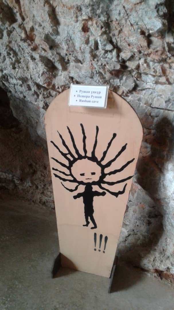
In general, Ornok petroglyphs are similar to Cholpon-Ata engravings by their technique, style, and dating. However, their themes are more diverse, with images of people with a careful depiction of costume details, mounted warriors (battle scenes), very large images of deer, an anthropomorphic figure of “the sun-headed”, and solar signs.
Jalal-Abad Region
Saimalu Tash
Saimaluu Tash (meaning ’embroidered’ or ‘patterned stones’ in Kyrgyz) is a petroglyph site in northern Jalal-Abad Province, , south of Kazarman. The road southwest to Jalal-Abad city normally requires a 4×4 as far as the Kaldama Pass over the Ferghana range. Once over the pass the country opens out to the Ferghana Valley. The road east through Baetov and Dostuk to Naryn is somewhat better
Over 10,000 carved pictures, which are black-and-white rock paintings, have so far been identified, making the site a globally important collection of rock art. They are a sacred display of offerings of the ancient people of the lower valley.


The site was proposed for listing under the UNESCO List of World Heritage Sites by the Kyrgyz National Commission for UNESCO on 29 January 2001. It is listed under the UNESCO’s Tentative List as “Saimaly-Tash Petroglyphs” for inscription under Cultural Category under Criteria: (iii), (iv) and (vi)
Talas Region
There are 40 known petroglyph sitees in Talas Region. The most important are
- a group of high-altitude sites in the upper reaches of the Ur-Maral River including Zhaltyrak-Tash, and Chiyim-Tash, (2,000–3,500m).
- a group of locations in a medium-altitude hill terrain in the valley of the Kenkol and Karakol Rivers and their tributaries (1,300–1,900m)
- a location in the southwestern zone Maymak, Kurkuro-Suu.
- Kulan-Say Gorge
The Talas Valley is located in the north-west of Kyrgyzstan between the Kyrgyz Alatoo Range in the north-east and the Talas Alatoo Range in the south, which converge in the east and then diverge in the west.
The Talas valley was populated in the Old Stone Age. During the Late Bronze Age, it was inhabited by tribes categorized as Andronovo historical-cultural community, as evidenced by findings from burial grounds Tash-Tubye-2, Tosh-Bashat, Besh-Tash, and others.
Sites of Early Iron Age ancient nomads are well represented; especially, in the Talas Valley where catacomb burials dated to “the great migration of peoples” were found for the first time.
Exploration of the petroglyphs in the Talas Valley dates to the late 19th century, when, in 1896, Kallaur V.-A. during his search for runic inscriptions in its upper reaches, registered petroglyphs at Chiyim-Tash. The study of Talas River Basinrock art sites was mostly done in its upper reaches, less frequently in its middle reaches, while its north-western, western, and south-western borders have been neglected by researchers with discoveries yet to be made.
In 1937, Kulan-Say Gorge petroglyphs were rediscovered by an expedition from the Kyrgyz State Institute of Pedagogy. Arabic and Sogdian inscriptions were also found
Petroglyphs are also located in different parts of the valley including Teke-Tash, Kurgan-Tash, Terek, Kulan, Karakol, Kugandy, Kurkuro-Suu and Ur-Mara
The largest number of drawings- (546 rocks) can be found in the intermountain valleys of Kenkol River and its tributaries. The petroglyphs are made on spurs of rock, rock debris and boulders covered with patina. The repertoire is dominated by mountain goats, (362 in Obo alone)
The petroglyphs is the upper reaches of the Ur-Maral tributaries (Zhaltyrak-Tash and Chiyim-Tash), located near high mountain passes, include some very large and extensive rock carvings across ancient glacier cirques.
Petroglyphs and runes in the western part of the valley can be found at Kuru-Bakayir (Talas Ala-Too) Gorge . Zhaltyrak-Tash (Ur-Maral)
Petroglyphs in the foothills of the Talas Range to the south of Beysheke village, are concentrated in the valley of the Ur-Maral River and its left tributary Chiyim-Tash, in Kyrgyz Ala-Too along the Kenkol River tributaries –Terskol and Chachykey, and on the territory of the “Manas-Ordo” Complex
In 2006, the staff of MC “Manas-Ordo” discovered two petroglyphic locations in the upper reaches, one located below a mountain pass (Otmek), while the other was behind the mountain pass, as far as Suucamyr.
Kenkol River Valley
The mountain valley of the Kenkol River is located between the main range of Kyrgyz Ala-Too and its spur Kara-Zhylga. The archeological complex in the Kenkol River Valley and its tributaries consists of sites heterogeneous in time and types attributable to nomads. Petroglyphs were registered along the tributaries: Bakay-Tobo, Terek, Chachykey, Obo, Korgon-Tash, Iyri-Kolot, Terskol, Boorusay, and Chochoy.
Over 546 surfaces with petroglyphs were registered there including in the gorges: Obo-90, Korgon-Tash-26, Chachykey-298, Chochoy-127, Iyri-Kolot-3, Bakay-Toboe-1, and near the Kenkol River bend–1.
Petroglyphs in Kamyrdynbeli and Mount Karaul-Choku can also be put in this group. They are near the estuary of the Kenkol River within the territory of the “Manas-Ordo” Complex, with over 80 engraved surfaces.
Petroglyphs are often concentrated near rivers in the lower parts of gorges, on open surfaces of steep rock shelters and on boulders covered with patina. The rocks are sandstone and shale.
The method of pecking is mainly with a fine-dot technique, but large-dot and engraving techniques are also found. The pattern types are: silhouettes, contours, line and sketches. Images and motifs are rather homogeneous.
Pictures of wild and domesticated animals, especially mountain goats, isolated or in groups, are predominant; at Obo alone there are 362 drawings. At the same time, each concentration offers more unconventional motifs: at Chochoy–a chariot and a large surface with 59 pictures of various animals and hunting scenes; at Chachykey – hunting scenes, ritual scenes, landscape elements; at Obo – a chariot and others.
Karakol and Uch-Koshoy River Valleys Petroglyphs
The Karakol River Valley is one of the best areas for high-altitude pastures in the Talas Ala-Too Range and has thus been used since the Bronze Age; active use of the area continued, as eloquently evidenced by archeological sites –burial mounds, petroglyphs, stone statues, epigraphy, and tash-koroo.
In 2005, members of the Talas Archeological Party (led by Amanbaeva B.-E.) registered two more concentrations–Tuyuk-Tor and Uch-Chat.
The Tuyuk-Tor petroglyphs are on an alluvial cone along the bed of the river–the right tributary of the Karakol River. The drawings were made on boulders of varying sizes. A huge boulder known among the locals as Chiyim-Tash has the main panel, with drawings of chariots, wagons, goats, camels, riders, including one with a standard, people, erotic scenes, solar signs with dots in the center.
Most are made using line contour and outline styles. Partial refreshing of the drawings has been found. There are many incomplete outline drawings and individual runic letters. The drawing technique is homogenous: dotted pecking up to 2-2.5mm deep. Tentative dating ranges from the Bronze Age to the Late Middle Ages.
None of these drawing concentrations are officially protected. Until recently, these gorges had been used as summertime pastures (dzhayloo), but due to recent construction of new motorways and plans for industrial construction, traditional land use is threatened and cultural sites, including petroglyphs, are at risk.
Ur Maral RIver
The Ur-Maral River is a left tributary of the Talas River and is 69km long and has 207 tributaries, the largest being the Besh-Kol, Kara-Koyun, Chiyim-Tash, and Chon-Zhol. The main types of landscape are steppes ranging from 1,100 to 1,600m above sea level and meadow-forests at an altitude of 2,000–2,700m.
Rock art is often found around the estuary and upper reaches of the Ur-Maral River. There are few petroglyphs in its lower and middle reaches, mainly on individual boulders and sometimes rock shelters. Rock art in the upper reaches of the river is commonly found in areas of bedrock outcrops located across glacier cirque beds near the estuaries of the Kandybaytor and Chiyim-Tash Rivers.
Zhaltyrak-Tash
Zhaltryak or (“Sparkling Rock”) is located on the left bank of the Kaman-Suu River at an altitude of 2500m. The rock is noted for its compactness and an oblong slate cliff stretches for 140-180m across the valley from west to east and 13 to 18m high with back glossy surface. The cliff surface is covered with a thick crust of bluish black desert patina
Zhaltyrak-Tash resembles a multi-layered site with a long time range–from the Bronze Age to Ethnographic Modernity.
The most ancient drawings include drawings of animals made in a bi trigonal style that have analogues in Saymaly-Tash. Wagons, chariots, humans, erotic scenes, and others date to the Advanced Bronze. The most diverse complex dates to the Early Iron Age and consists of many animals completed in the Scythian-Siberian style with analogues in the vast Eurasian space.
Petroglyphs differ in size and technique. Most are made using a deep dotted technique in combination with abrading, which ensures precision. This technique is characteristic of the earliest petroglyphs dated to the Bronze Age and Early Iron Age, but it remained unchanged in later times.
In addition, an engraving technique was used in Turkic and later times. Petroglyph sizes vary greatly. There is a multitude of small drawings 4–5cm to 8–10 cm long. Drawings up to 1-2m are also found. Double and even triple superimpositions of drawings occur.
The repertoire of images is diverse and includes depictions of different animals, predominantly goats. Other commonly found animals are deer, camels, boars, and also easily recognizable predators: snow leopards, bears, tigers and others. Fantastic creatures, such as centaurs and dragons, were also registered, as well as a significant number of chariots, wagons, hunting and erotic scenes.
Chiyim-Tash
Chiyim-Tash is in the upper reaches of the Chiyim-Tash valley. The river is a left tributary of the Ur-Maral River at the foot of a mountain pass with the same name (3,601m altitude). Several slate blocks, 10m high, 80m long and 10m wide, stretch NE-SW with a 15-20° inclination south. Many petroglyphs with superimpositions are found on their vertical and horizontal surfaces facing north-west. In front of the rocks, horizontal stone sites were possibly used to perform certain ritual acts.
Engraved surfaces are on the north side. Larger drawings are found on top of the rock. There is a total of more than 1,000 petroglyphs.
Most drawings depict animals (goats, deer, camels, horses, dogs, predators, and others) and humans (including archers in hunting scenes), chariots, wagons, tamga signs and undeciphered ancient inscriptions, as well as inscriptions of visitors in Arabic script from the 19th-20th centuries. The structure of chariots depicted on one of the horizontal surfaces is of special interest.
The drawing technique varies: pecking with large and fine dots, notching, and engraving. The pecking depth is 1–4 mm. Tentative dating goes from the Bronze Age to New Times inclusively.
Chuy Region
Burana Tower Complex
Petroglyphs and balbals, (stone grave markers) from the Chui region have been gathered,
Ak-Chunkur
(“white cave”)
Sary Jaz
paintings in Sary Jaz (“Golden Valley”) deep in the Tien Shan Mountains; in Aravan
Learn More
Must See Ancient Petroglyph Sites in Kyrgystan – Silk Road Expore.com
Kyrgzstan Petroglyphs – Eur Asia Travel

I like your work research, good informations for my tour.Thanks.
LikeLike
Thank you so much.
Let us know what questions you have.
Mark
LikeLike
Very interesting post.
LikeLike
Thanks for your interest. I am working on understanding the Bronze Age in Central Asia now. So far, I have learned that the culture in Northern Central Asia was pastoral and the culture in Southern Central Asia was more settled. There was a large Bronze Age town near Merv in Turkmenistan.
It is a fun part of this Silk Road Project to try to figure out what these Petroglyphs mean and how visitors can see them.
Let me know what questions you have and we will try to find out.
Mark
LikeLike
Dear Markeminer,
You mentioned Zoroastrians in connection to Suleyman muzeum, what is the information on Zoroastrians on the former territory of Kyrgyztan?
A.
LikeLike