
The Chuy Valley has four different UNESCO World Heritage sites.
Chuy Region on the Silk Road
Sogdiana
Sogdiana or Sogdia was an ancient Iranian civilization that at different times included territory located in present-day Tajikistan and Uzbekistan (See our Uzbek page for more details on the Sogdianas) such as: Samarkand, Bukhara, Khujand, Panjikent and Shahrisabz.

Sogdiana was also a province of the Achaemenid Empire, (550–330 BC), also called the First Persian Empire led by same Cyrus the Great and Darius who famously battled the Greeks.
The region was annexed by the Macedonian ruler Alexander the Great in 328 BC. The region would continue to change hands under the Seleucid Empire, Greco-Bactrian Kingdom, Kushan Empire, Hephthalite Empire, and Sasanian Empire.
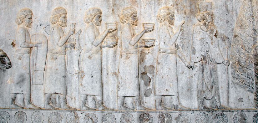
Sogdians on an Achaemenid Persian relief from the Apadana of Persepolis, offering tributary gifts to the Persian king Darius I, 5th century BC
Dulu and Nushibi Turks
The Dulu Turks (were a tribal confederation in the Western Turkic Khaganate (c581-659). The Turgesh Khaganate (699-766) may have been founded by Dulu remnants. A relation to the Dulo clan of the Bulgars is possible but not proven.
TheDulu Turks lived between Lake Balkash and the Tian Shan Mountains. and were probably more pastoral than their neighbors. Rivers running down from the Tianshan supported agriculture and towns and thus a natural caravan route. The Dulu presumably taxed these people. The West Turkic Khagans had a capital at Suyab near the Dulu-Nushibi boundary.
The Nushibi confederation were the Dulu’s western neighbors and their territory extended west to the Syr Darya and southward. The boundary between the two was around the Ili River and the Chu River, that is, near a line running south from the southwest corner of Lake Balkash. The Nushibi had connections southwest with the literate Sogdian merchants.
The Western Turks were also called the Onoq or ‘ten arrows’, that is ‘ten tribes’, possibly five for the Dulu and five for the Nushibi. There is confusion, or possibly connection, with the earlier Onogurs which also means ‘ten tribes’.
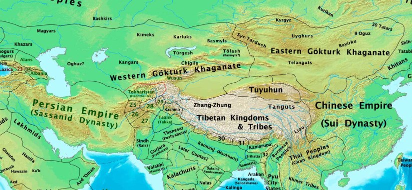
Western Turkic Khagnate
The Western Turkic Khaganate ‘s capitals were Navekat (the summer capital) and Suyab (the principal capital), both situated in the Chuy River valley. Tong Yabgu’s summer capital was near Tashkent and his winter capital Suyab.
It was formed as a result of the wars in the beginning of the 7th century (AD 593–603) after the split of the Göktürk Khaganate (founded in the 6th century in Mongolia by the Ashina clan) into the Western khaganate and the Eastern Turkic Khaganate.
At its height, the Western Turkic Khaganate included what is now Kazakhstan, Uzbekistan and parts of Kyrgyzstan, Tajikistan, Turkmenistan and Russia.
The ruling elite or perhaps the whole confederation was called Onoq or “ten arrows”, possibly from oğuz (literally “arrow”), a subdivision of the Turkic tribes. A connection to the earlier Onogurs, which also means ‘ten tribes’, is questionable.
The first Turkic Khaganate was founded by Bumin in 552 in Mongolia and quickly spread west toward the Caspian. The Gokturks and Mongols were the only two empires to rule both the eastern and central steppe. The Gokturks were the first steppe empire to be in contact with three great agrarian civilizations: Byzantium, Persia and China.
Within 35 years the western half and the Eastern Turkic Khaganate were independent. The Western Khaganate reached its peak under the greateast Khaghan Tong Yabghu Qaghan (618–630). He ruled from the Tarim basin to the Caspian, met Xuanzang (, sent men to fight the Persians south of the Caucasus and sent his son Tardush Shad to fight in Afghani
After Tong Yabghu’s murder there were conflicts between the Dulu and Nushibi factions, many short-lived Khagans and some territory was lost. From 642 the expanding Tang dynasty Chinese began interfering. The Tang destroyed the Khaganate in 657–659.
Turkic rule in Mongolia was restored as Second Turkic Khaganate in 682.
n the year of his death the Chinese overthrew the Eastern Khaganate in Mongolia. He was murdered by his uncle Külüg Sibir (630) with Dulo support. The Nushibi put Tong’s son Irbis Bolun Cabgu (631-33) on the throne. The Nushibi rebelled and enthroned Dulu Khan(633-34) who was followed by his brother Ishbara Tolis (634-38). There was a Dulu-Nushibi conflict and Yukuk Shad (638-42), son of the final eastern Khagan, was brought in. The factions quarreled and the Nushibi and Emperor Taizong of Tangenthroned Irbis Seguy (642-51). The Chinese demanded part of the Tarim Basin and then seized part of it until the war was stopped by Taizong’s death. Irbis was overthrown by Ishbara Qaghan (Ashina Helu) (651-58) who, after about six years of war, was captured by the Chinese. See Conquest of the Western Turks. After this there were several puppet Khagans. In 679-719 the old Gokturk capital of Suyab was one of the Four Garrisons of Anxi. The Chinese remained in the area until the time of An Lushan’s rebellion (756).
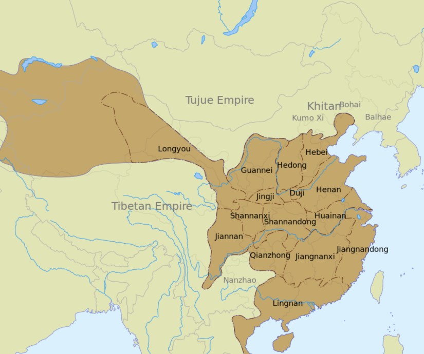
Anxi Protectorate (640 – 790)
The Protectorate General to Pacify the West, was established by the Tang Dynasty in 640 to control the Tarim Basin. Its headquarters was established at the prefecture of Xi, now known as Turpan, but was later shifted to Qiuci (Kucha) and situated there for most of the period.
The Four Garrisons of Anxi in Kucha, Khotan, Kashgar, and Karashahr were installed between 648 and 658 as garrisons under the western protectorate. In 659 Soghd, Ferghana, Tashkent, Bukhara, Samarkand, Balkh, Herat, Kashmir, the Pamirs, Tokharistan, and Kabul all submitted to the protectorate under Emperor Gaozong of Tang.
After the An Lushan Rebellion the office of Protector General was given to Guo Xin who defended the area and the four garrisons even after communication had been cut off from Chang’an by the Tibetan Empire. The last vestiges of the protectorate and its garrisons were defeated by Tibetan forces by the year 790, ending nearly 150 years of Tang influence in central Asia.
Tokmok
Despite its relatively modern origin, Tokmok stands in the middle of the Chuy Valley, which was a prize sought by many medieval conquerors. The ruins of Ak-Beshim, the capital of the Western Turkic Khaganate, are situated 8 km southwest from Tokmok. Yusuf Has Hajib Balasaguni, author of the Kutadgu Bilig is said to have been born in this area.
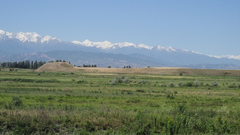
About 15 km south of Tokmok is the 11th-century Burana Tower, located on the grounds of an ancient citadel of which today only a large earthen mound remains. This is believed to be the site of the ancient city of Balasagun, founded by the Sogdians and later for some time the capital of the Kara-Khanid empire. A large collection of ancient gravestones and bal-bals is nearby. Excavated Scythian artifacts have been moved to museums in St. Petersburg and Bishkek.
Suyab
(Ak-Beshim is the modern name). Suyab was an ancient Silk Road city located some 50 km east from Bishkek, and 8 km west southwest from Tokmok, in the Chui River valley.
The settlement of Sogdian merchants sprang up along the Silk Road in the 5th or 6th centuries. Sogdiana or Sogdia was an ancient Iranian civilization that at different times included territory located in present-day Tajikistan and Uzbekistan (See our Uzbek page for details) such as: Samarkand, Bukhara, Khujand, Panjikent and Shahrisabz. Sogdiana was also a province of the Achaemenid Empire, (550–330 BC), also called the First Persian Empire led by same Cyrus the Great and Darius who famously battled the Greeks.
The name of the city derives from that of the Suyab River, whose origin is Iranian (in Persian: suy means “toward”+ ab for “water”, “rivers”). It was first recorded by Chinese pilgrim Xuanzang who travelled in the area in 629:
Traveling 500 li to the north west of Great Qing Lake, we arrive at the city of the Suye River. The city is 6 or 7 li in circuit; various Hu (“barbarian”) merchants here came from surrounding nations congregate and dwell. The soil is favourable for red millet and for grapes; the woods are not thick, the climate is windy and cold; the people wear garments of twilled wool. Traveling from Suye westward, there are a great number of isolated towns; in each there is a chieftain; these are not dependent on one another, but all are in submission to the Tujue.
During the reign of Tong Yabgu Qaghan, Suyab was the principal capital of the Western Turkic Khaganate. The khagan also had a summer capital in Navekat near the springs north of Tashkent in the Talas Valley, the capitals are being noted as the westernmost capital of Western Turkic Khaganate. There was a sort of symbiosis, with the Sogdians responsible for economical prosperity and the Gokturks in charge of the city’s military security.
Tong Yabghu maintained close relations with the Tang Dynasty of China, and may have married into the Imperial family. The Chinese Buddhist pilgrim Xuanzang visited the western Göktürk capital Suyab and left a description of the khagan. Scholars believe the khagan described by Xuanzang was Tong Yabghu.
The khan wore a green satin robe; his hair, which was ten feet long, was free. A band of white silk wound round his forehead and hung down behind. The ministers of the presence, numbering two hundred in number, all wearing embroidered robes, stood on his right and left. The rest of his military retinue [was] clothed in fur, serge and fine wool, the spears and standards and bows in order, and the riders of camels and horses stretched far out of [sight].
Following the downfall of the khaganate, Suyab was absorbed into the Tang Empire, of which it was a western military outpost between 648 and 719. A Chinese fortress was built there in 679, and Buddhism flourished.
According to some accounts, the great poet Li Bai (701–762), was born in Suyab. Li Bai was acclaimed from his own day to the present as a genius and a romantic figure who took traditional poetic forms to new heights. He was one of the most prominent figures of the Golden Age of Chinese Poetry which flourished during the Tang Dynasty,
The poems were models for celebrating the pleasures of friendship, the depth of nature, solitude, and the joys of drinking wine. Among the most famous are “Waking from Drunkenness on a Spring Day”, “The Hard Road to Shu”, and “Quiet Night Thought“, which still appear in school texts in China. . His life has taken on a legendary aspect, including tales of drunkenness, chivalry, and the well-known fable that Li drowned when he reached from his boat to grasp the moon’s reflection in the river.


The Chinese traveller Du Huan, visited Suyab after 751 and found among the ruins a still-functioning Buddhist monastery, where Princess Jiaohe, daughter of Ashina Huaidao (a puppet khagan under Tang dynasty) , used to dwell.
Suyab was one of the Four Garrisons of Anxi Protectorate until 719, when it was handed over to Sulu Khagan of the Turgesh, appointed by the Chinese court as the “Loyal and Obedient Qaghan”. After Sulu’s murder in 738, the town was promptly retaken by Chinese forces, along with Talas The fort was strategically important during the wars between China and Tibet. In 766, the city fell to a Qarluq ruler, allied with the nascent Uyghur Khaganate.
Of the subsequent history of Suyab there is little record, especially after the Chinese evacuated the Four Garrisons in 787. David Nicolle states that Suyab provided 80,000 warriors for the Qarluq army and that it was governed by a man known as “King of Heroes”. n Hudud al-Alam, completed in 983, lists Suyab as a city of 20,000 inhabitants. It is believed to have been supplanted by Balasagun in the early 11th century and was abandoned soon thereafter.
In the 19th century the ruins at Ak-Beshim were erroneously identified with Balasagun, the capital of the Kara-Khitans. Wilhelm Barthold, who visited the site in 1893-94, also lent his support to this identification. Although excavations started in 1938, it was not until the 1950s that it was determined that the site had been abandoned as early as the 11th century and therefore would not be identical with Balasagun, which had flourished until the 14th century.
The archaeological site of Suyab covers some 30 hectares. As a testimony to Suyab’s diverse and vibrant culture, the site encompasses remains of Chinese fortifications, Christian churches, Zoroastrian ossuaries, and Turkic bal-bals. The site is particularly rich in finds of Buddha statues and stelae. Apart from several Buddhist temples, there were a Nestorian church and cemetery from the 7th century, and probably also a 10th-century monastery with frescoes and inscriptions in Sogdian and Uyghur scripts.
Burana Tower (Balasagun ruins).
A large minaret in the Chuy Valley in northern Kyrgyzstan, located about 80 km east of the country’s capital Bishkek, near the town of Tokmok. The tower, along with grave markers, some earthworks, and the remains of a castle and three mausoleums, are all that remain of the ancient city of Balasagun,, an ancient city that was founded by the Karakhanids at the end of the 9th century. An external staircase and steep, winding stairway inside the tower allow visitors to climb to the top

The tower was originally 45 m (148 ft) high. However, over the centuries a number of earthquakes caused significant damage to the structure. The last major earthquake in the 15th century destroyed the top half of the tower, reducing it to its current height of 25 m (82 ft). In the early 1900s, Russian immigrants to the area used some of the bricks from the tower for new building projects. A renovation project was carried out in the 1970s to restore its foundation and repair the west-facing side of the tower, which was in danger of collapse.
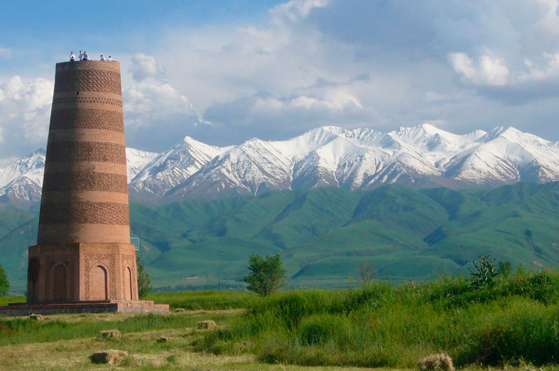
The entire site, including the mausoleums, castle foundations and grave markers, now functions as museum and there is a small building on the site containing historical information as well as artifacts found at the site and in the surrounding region.
A legend connected with the tower says that a witch warned a local king that his newly-born daughter would die once she reached the age of eighteen. To protect her, he built a tall tower where he sequestered his daughter. No one entered the tower, except the daughter’s servant who brought her food. The daughter grew up alone and became a beautiful young lady. One day, however, a poisonous spider was hiding in the food brought by the servant. The spider bit the girl, and she died in the tower, at the age of eighteen.
Navekat (Krasnorechenskoe ruins)
Navekat or Nevkat, was an ancient Silk Road city that flourished between the 6th and 12th centuries. It lies near modern village of Krasnaya Rechka, in the Navekat or Nevkat , about 30 kilometers east of Bishkek. It was one of the most important trading centres of the region,
Navekat or Nevkat was an ancient Silk Road city that flourished between the 6th and 12th centuries. It lies near modern village of Krasnaya Rechka, in the Chui River valley, present-day Kyrgyzstan, about 30 kilometers east of Bishkek. It was one of the most important trading centres of the region
Learn More
The Sogdians of the Silk Road Blogspot
Sogdiana Historical Geography – Encyclopedia Iranica

4 thoughts on “Chuy Region”