

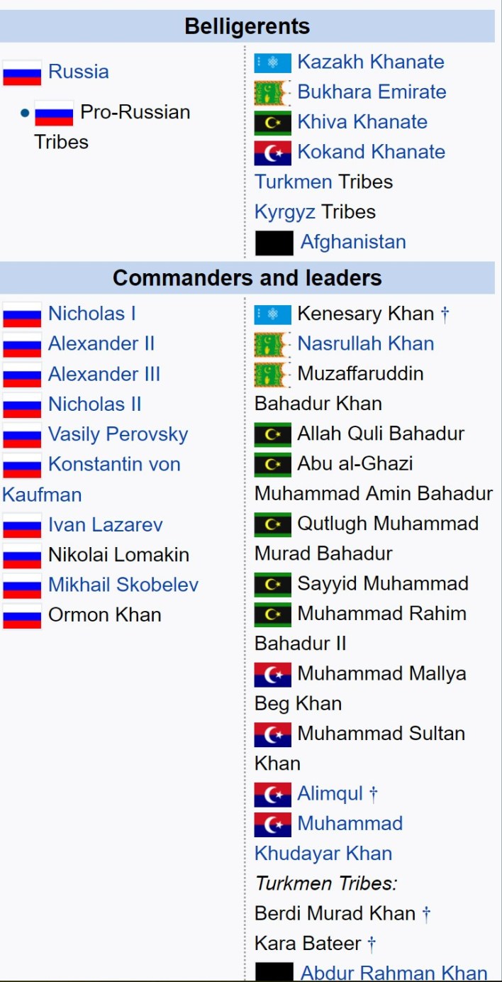
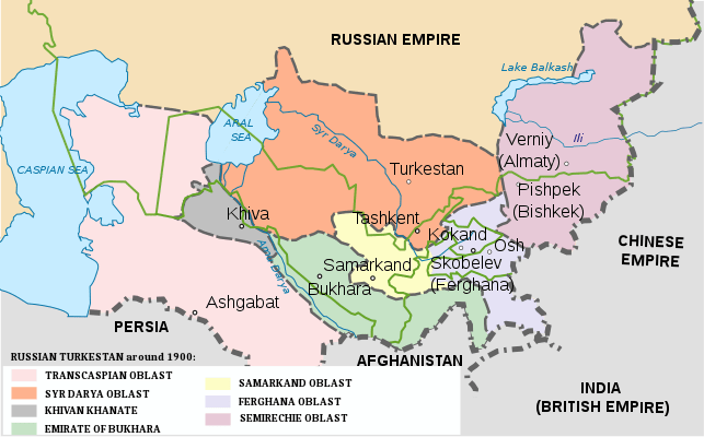
 The Russian Conquest of Central Asia took place in the second half of the nineteenth century. The land that became Russian Turkestan and later Soviet Central Asia is now divided between Kazakhstan in the north, Uzbekistan across the center, Kyrgyzstan in the east, Tajikistan in the southeast and Turkmenistan in the southwest. The area was called Turkestan because most of its inhabitants spoke Turkic languages with the exception of Tajikistan, which speaks an Iranian language.
In the eighteenth century Russia gained increasing control over the Kazakh steppe. In 1839 they failed to conquer the Khanate of Khiva south of the Aral Sea. In 1847-53 they built a line of forts from the north side of the Aral Sea eastward up the Syr Darya River. In 1847-1864 they crossed the eastern Kazakh steppe and built a line of forts along the northern border of Kyrgyzstan. 1864-1868 they moved south from Kyrgyzstan, captured Tashkent and Samarkand and dominated the Khanates of Kokand and Bukhara.
They now held a triangle whose southern point was 1000 miles south of Siberia and 1200 miles southeast of their supply bases on the Volga. The next step was to turn this triangle into a rectangle by crossing the Caspian Sea. In 1873 they conquered Khiva. In 1881 they took western Turkmenistan. In 1884 the Merv oasis and eastern Turkmenistan were taken. In 1885 expansion south toward Afghanistan was blocked by the British. In 1893-95 they occupied the high Pamirs in the southeast.
Syr Darya Line
Southward from the Siberian Line the obvious next step was a line of forts along the Syr Darya River eastward from the Aral Sea. This brought Russia into conflict with the Khan of Kokand. In the early 19th century Kokand began expanding northwest from the Fergana Valley. About 1814 they took Hazrat-i-Turkestan on the Syr Darya and around 1817 built Ak-Mechet (‘White Mosque’) further downriver, as well as smaller forts on both sides of Ak-Mechet. The area was ruled by the Beg of Ak Mechet who taxed the local Kazakhs who wintered along the river and had recently driven the Karakalpaks southward. In peacetime Ak-Mechet had a garrison of 50 and Julek 40. The Khan of Khiva had a weak fort on the lower part of the river.
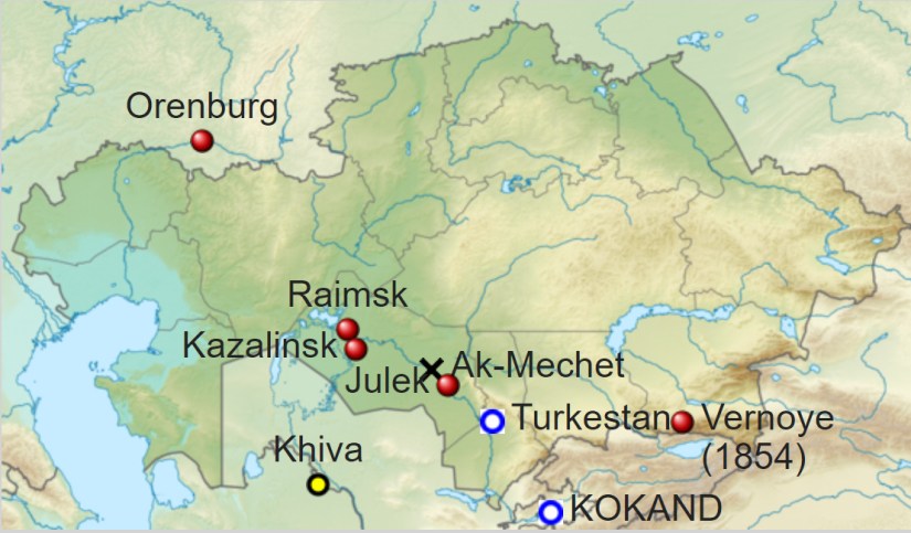
Given Perovsky’s failure in 1839 Russia decided on a slow but sure approach. In 1847 Captain Schultz built Raimsk in the Syr delta. It was soon moved upriver to Kazalinsk. Both places were also called Fort Aralsk. Raiders from Khiva and Kokand attacked the local Kazakhs near the fort and were driven off by the Russians.
Three sailing ships were built at Orenburg, disassembled, carried across to steppe and rebuilt. They were used to map the lake. In 1852/3 two steamers were carried in pieces from Sweden and launched on the Aral Sea.
In 1852 a surveying party went upriver and was turned back before reaching Ak-Mechet. That summer Colonel Blaramberg and about 400 men were sent to raze Ak-Mechet on the pretext that Russia owned the north side of the river.
The Kokandis responded by breaking the dykes and flooding the surrounding area. Having brought no scaling ladders or heavy artillery, Blaramberg saw that he could not take the citadel with its 25-foot-high walls. He therefore captured the outworks, burnt everything in the area and retired to Fort Aralsk.
Next summer the Russians assembled a force of over 2000 men, over 2000 each of horses, camels and oxen, 777 wagons, bridging timber, pontoons and the steamer “Perovsky”. To guarantee that there would be enough fodder to move this much from Orenburg to Fort Aralsk, the Kazakhs were forbidden to graze the lands north of the fort. Command was given to the same Perovsky who earlier had failed to reach Khiva.
A regular siege of Ak-Mechet was begun. When the trenches neared the citadel, a mine was dug under the walls. At 3AM on 9 August 1853 the mine was exploded, creating a large breach. The breach was taken on the third try and by 4:30AM it was all over. 230 Kokandi bodies were counted out of the original 300-man garrison. The place was renamed Fort Perovsky.(today’s Kyzylorda, Kazahkstan.)

During the siege Padurov went 100 miles upriver to Julek and found that its defenders had fled. He wrecked the fort as well as he could and returned with its abandoned guns. In September a large force from Kokand reoccupied Julek and advanced toward Fort Perovsky. The column sent to meet them had a hard day’s fight, called for reinforcements but next morning found that the Kokandis has retreated. In December a Kokandi force (said to be 12000 men) surrounded Fort Perovsky. A 500-man sortie was soon surrounded and in trouble. Major Shkupa, seeing the enemy camp weakly defended, broke out and burned the camp. Two more sorties drove the Kokandis off in disorder.
Russia now held a 200-mile line of forts along the west-flowing part of the Syr Darya. The area between the Aral and Caspian Seas was too thinly-populated to matter. The next question was whether Russia would extend the line east to the mountains (Fort Vernoye was founded in 1854 and is today’s Almaty, Kazakhstan) or continue southeast up the river to Kokand and the Fergana Valley.
In 1847-1864 the Russians crossed the eastern Kazakh steppe and built a line of forts in the irrigated area along the northern Kyrgyz border.
 The main event of the conquest occurred in 1864-68 when the Russians moved south, conquered Tashkent and Samarkand, confined the Khanate of Kokand to the Ferghana Valley and made Bukhara a protectorate.
An eastern approach may haven been chosen, because irrigation made it possible to move armies without crossing steppe or desert. This was important when transport required grass-fed horses and camels. It seems that different officials had different opinions and much was decided by local commanders and the luck of the battlefield.
All sources report Russian victories over greatly superior forces with kill ratios approaching ten to one. Even if enemy numbers are exaggerated it seems clear that Russian weapons and tactics were far superior to the traditional Asian armies that they faced.
All sources mention breachloading rifles without further explanation. MacGahan, in his account of the Khivan campaign, contrasts explosive artillery to traditional cannonballs. Artillery and rifles could often keep Russia soldiers out of reach of hand weapons.
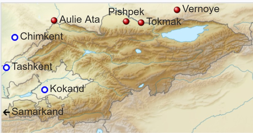
The eastern end of the Kazakh steppe was called Semirechye by the Russians. South of this, along the modern Kyrgyz border, the Tian Shan Mountains extend about 400 miles to the west. Water coming down from the mountains provides irrigation for a line of towns and supports a natural caravan route.
South of this mountain projection is the densely-populated Ferghana Valley ruled by the Khanate of Kokand. South of Ferghana is the Turkestan Range and then the land the ancients called Bactria. West of the northern range is the great city of Tashkent and west of the southern range is Tamerlane’s old capital Samarkand.
 In 1847 Kopal was founded southeast of Lake Balkash.
In 1852 Russia crossed the Ili River and met Kazakh resistance and next year destroyed the Kazakh fort of Tuchubek.
In 1854 they founded Fort Vernoye (Almaty) within sight of the mountains, about 500 miles south of the Siberian Line.
Eight years later, in 1862, Russia took Tokmok in the Chuy Region of Kyrgyzstan and Pishpek (Bishkek). Russia placed a force at the Kastek Pass to block a counterattack from Kokand.
The Kokandis used a different pass, attacked an intermediate post, Kolpakovsky rushed from Kastek and completely defeated a much larger army. In 1864 Chernayev took command of the east, led 2500 men from Siberia, and captured Taraz. Russia was now near the west end of the mountain range and about halfway between Vernoye (Almaty) and Ak-Mechet.
In 1851 Russia and China signed the Treaty of Kulja to regulate trade along what was becoming a new border. In 1864 they signed the Treaty of Tarbagatai which approximately established the current Chinese-Kazakh border. The Chinese thereby renounced any claims to the Kazakh steppe, to the extent that they had any

Meanwhile, Russia was advancing southeast up the Syr Darya from Ak-Mechet. In 1859 Julek was taken from Kokand and in 1861 a Russian fort was built here and in the same year Yani Kurgan (Zhanakorgan?) fifty miles upriver was taken. In 1862 Chernyaev reconnoitered the river as far as Hazrat-i-Turkestan and captured the small oasis of Suzak about 65 miles east of the river. In June 1864 Veryovkin took Hazrat-i-Turkestan from Kokand. He hastened surrender by bombarding the famous mausoleum. Two Russian columns met in the 150-mile gap between Hazrat and Aulie-Ata, thereby completing the Syr-Darya Line
About 50 miles south of the new line was Chimkent (Shymkent) which belonged to Kokand. Chernayev easily took it on 3 October 1864. On 15 October he suddenly appeared before Tashkent, failed to take it by sudden assault and retreated to Chimkent.
Kokand then tried and failed to re-take Hazrat-i-Turkestan. In April 1865 Chernayev made a second attack on Tashkent. Unable to take such a large place (it was said to have a garrison of 30,000) he occupied the town’s water supply at Niazbek. The Kokand Regent Alim Kuli arrived with 6,000 more troops and almost defeated the Russians, but was killed in the fight.
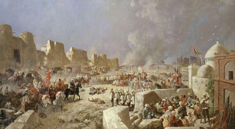
The inhabitants now offered to submit to the Emir of Bokhara in return for assistance. About 21 June a party of Bokharans entered the town and more Bokharan troops were on the move. In this critical position Chernayev deterimined to risk a storm. At 3 AM on 27 June Captain Abramov scaled the wall and opened the Kamelan Gate, advanced along the wall and opened a second gate while another party took the Kokand Gate. That day and the next there was constant street fighting, but on the morning of the 29th a deputation of elders offered surrender.
The Bokhara was now involved in the war. In February 1866 Chernayev crossed the Hungry Steppe to the Bokharan fort of Jizzakh. Finding the task impossible, he withdrew to Tashkent followed by Bokharans who were soon joined by Kokandis.
At this point Chernayev was recalled for insubordination and replaced by Romanovsky. Romanovsky prepared to attack Bohkara, the Amir moved first, the two forces met on the plain of Irjar.
The Bokharans were scattered, losing much of their artillery, supplies and treasure. Instead of following up, Romanovsky turned east and took Kojent, thereby closing the mouth of the Ferghana Valley. He then moved west and took Ura-Tepe and Jizzakh from Bokhara. Bokhara began peace negotiations.
In July 1867 a new Province of Turkestan was created and placed under General von Kaufmann with its headquarters at Tashkent. The Bokharan Amir did not fully control his subjects, there were random raids and rebellions, so Kaufmann decided to hasten matters by attacking Samarkand.
After he dispersed a Bokharan force Samarkand closed its gates to the Bokharan army and surrendered (May 1868). He left a garrison in Samarkand and left to deal with some outlying areas. The garrison was besieged and in great difficulty until Kaufmann returned.
On 5 July 1868 a peace treaty was signed. The Khanate of Bokhara lost Samarkand and remained a semi-independent vassal until the revolution. The Khanate of Kokand had lost its western territory, was confined to the Fergana Valley and surrounding mountains and remained independent for about 10 years.
Kurmanjan Datka (See my blog post)
Kurmanjan Datka (1811 – 1907) also known as “The Tsaritsa of Alai” or “The Queen of the South”, was a stateswoman in Kyrgyzstan who acquiesced under duress to the annexation of that region to Russia. She is now a national heroine. See My Russia page for the story of the Russian Conquest of Central Asia.
Kurmanjan was born into a rich family of the Mungush clan in the Osh. At the age of 18 she was supposed to be married to a man whom she did not see until her wedding day. When she met him, she did not like him and broke with tradition — first fleeing into neighboring China and later deciding to stay with her father, Mambatbai.


In 1832, the local feudal lord, Alimbek, who had taken the title, “Datka”, and ruled all the Kyrgyz of the Alai, was attracted by the young, vivacious woman, and married her. An instrumental politician in the increasingly decrepit Kokand Khanate, Alimbek was murdered in the course of a palace coup in 1862 and Kurmanjan was recognized by the khans of Bukhara and Kokand as ruler of the Alai and given the title of “Datka”. In 1876 the Alai region was annexed by the Russian Empire. Recognizing the futility of resistance, Kurmanjan Datka persuaded her people to accept Russian overlordship.
During the subsequent continuing unrest and sporadic attempts by the local population to shake off Russian supremacy, gun-running and smuggling were profitable businesses and two of Kurmanjan’s sons and two of her grandsons were charged with contraband trade and murdering customs officials.
When her favorite son was sentenced to death, she refused the urging of some of her followers to effect a rescue, saying that she would not let her private hopes and ambitions be the cause of suffering for her people; she actually attended her son’s public execution. The others were then exiled to Siberia and she essentially retired from public life.
This female leader featured on the 50-som note also is the star of the 2014 epic Kyrgyz film Kurmanjan Datka (Available or Free Public View on YouTube with English Subtitles HERE) which is the biggest budgeted Kyrgyz film to date and a world class epic on any scale. Real horse battles, not CGI,. we don’t make epics the way they used to.
Turkomen
The Turkoman country remained unconquered. The area corresponded to the Karakum Desert and was inhabited by the Turkoman desert nomads. Irrigation supported a settled population along the Amu-Darya in the northeast and along the north slope of the Kopet Dag mountains in the southwest.
East of the Kopet Dag two rivers flowing north from Afghanistan supported the oases of Tejend and Merv. The semi-settled population would drive their flocks out into the desert in spring and fall. The Turkomans had no organized state. Some served as mercenaries for Khiva. They had a habit of raiding Persia and selling the resulting slaves to Khiva. They also had a breed of desert-adapted horse that could usually outrun anything the Cossacks had. Unlike the rather antiquated armies of the Khanates, the Turkomans were good raiders and horsemen, but they could do little against the Russians’ modern weapons and explosive artillery. As usual, the main problem was moving men and supplies across the desert.
The irrigated area along the Kopet Dagh River ends east of Ashkebat. Further east there is desert, then the small oasis of Tejent, more desert and the much larger oasis of Merv. Merv had the great fortress of Kaushut Khan and was inhabited by the same Tekkes that fought at Geok Tepe.

As soon as the Russians were established in Ashkabad traders, and also spies, began moving between the Kopet Dagh and Merv. Some elders from Merv went north to Petroalexandrovsk and offered a degree of submission to the Russians there. The Russians at Ashkebat had to explain that both groups were part of the same empire. In February 1882 Alikhanov visited Merv and began talking to Makhdum Kuli Khan who had been in command at Geok Tepe. In September he persuaded him to take an oath of allegiance to the White Czar.
After Komarov’s occupation of Tejend , Alikhanov and Makhdum Kuli Khan went to Merv and called a meeting of elders, one threatening and the other persuading. Having no wish to repeat the slaughter at Geok Tepe, 28 elders went to Ashkabad and on February 12 took an oath of allegiance in the presence of General Komarov. A faction in Merv tried to resist but was too weak to accomplish anything. On March 16, 1884 Komarov occupied Merv. The subject Khanates of Khiva and Bokhara were now surrounded by Russian territory.
The Eastern Mountains
East of the Fergana Valley and southeast of Fort Vernoye on the other side of the mountains is the oval Tarim Basin which had belonged to China since 1759. During the Dungan Revolt (1862–77) China lost partial control of its western territories. A man named Yakub Beg made himself master of Kashgar and most of the Tarim Basin.
Kaufmann twice thought of attacking him. In 1872 forces were massed on the border but this was called off because of the impending war against Khiva. In 1875 more serious plans were made. A mission was sent to the Khan of Kokand to ask permission to move forces through his domains. A revolt broke out and the Russian troops were used instead to annex Kokand. In 1877 China re-conquered the Tarim Basin and Yakub Beg was killed.
The Tian Shan Mountains run along the northern border of Kyrgyzstan. They continue east and separate Dzungaria in the north from the Tarim Basin in the south. On the Chinese side the Borohoro Mountains branch off creating the upper Ili River valley with its capital of Kulja (modern Yining City).
Although normally part of Dzungaria the valley opens out onto the Russian-controlled steppe. In 1866 the Dungans captured Kulja and massacred its inhabitants. They soon began fighting with the Taranchis (Uigurs) who soon became dominant.
In 1870 it appeared that Yakub Beg might move on Kulja so Kaufmann occupied the Muzart Pass. In June 1871 General Kolpakovsky crossed the border and occupied Kulja (4 July 1871). Some talked of permanent occupation but the Russian Foreign Office told the Chinese that the province would be returned as soon as the Emperor could send enough troops to maintain order.
In 1877 China regained control of Chinese Turkestan and requested the return of Kulja. In September 1879 the Chinese ambassador concluded a treaty at Livadia but his government rejected it. This was replaced by the more favorable Treaty of Saint Petersburg (1881). Russia finally evacuated Kulja in the spring of 1883. The re-occupation of Kulja was one of the few Chinese successes against a Western power during the nineteenth century.
Fall of Kokand
By 1868 the Khanate of Kokand had been confined to the Fergana Valley and surrounding mountains. Kokand had always been unstable with many temporary factions and changes of regime. A rebellion broke out in 1873. By July 1875 most of the Khan’s army and much of his family had deserted to the rebels, so he fled to the Russians at Kojent along with a million British pounds of treasure. The rebels wanted to fight the Russians as well as the Khan and Kojent was briefly besieged. Kaufmann invaded the Khanate on September 1, fought several battles and entered the capital on September 10, 1875. Fighting continued outside the capital. As soon as one group of rebels was defeated another would appear somewhere else. Kokand was formally annexed on March 2, 1876, but disorder continued, especially in the mountains.
The Final Piece – The High Pamirs
The southeast corner of Russian Turkestan was the high Pamirs which is now the Gorno-Badakhshan Autonomous Region of Tajikistan. The high plateaus on the east are used for summer pasture. On the west side difficult gorges run down to the Panj River and Bactria.
In 1871 Alexei Fedchenko got the Khan’s permission to explore southward. He reached the Alay Valley but his escort would not permit him to go south onto the Pamir plateau. In 1876 Skobelev chased a rebel south to the Alay Valley and Kostenko went over the Kyzylart Pass and mapped the area around Karakul Lake on the northeast part of the plateau. (See details about the Kyzylart Pass on my Osh Region and Osh Region Adventure pages)
In the next 20 years most of the area was mapped. In 1891 the Russians informed Francis Younghusband that he was on their territory and later escorted a Lieutenant Davidson out of the area (‘the Pamir Incident’).
In 1892 a battalion of Russians under Mikhail Ionov entered the area and camped near the present Murghab, Tajikistan in the northeast. Next year they built a proper fort there (Pamirskiy Post). In 1895 their base was moved west to Khorog facing the Afghans. In 1893 the Durand Line established the Wakhan Corridor between the Russian Pamirs and British India.
The Great Game
The Great Game tefers to British attempts to block Russian expansion southeast toward India. The Great Game came to an end with the demarcation of the northern Afghan border in 1886 and 1893 and the Anglo-Russian Entente of 1907.
Learn More
Kyzylorda – Eurasia Travel

3 thoughts on “Russian Conquest of Central Asia”