
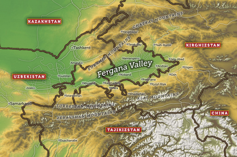
Khujand is mostly likely on the same site as Alexandria Eschatea (Greek Ἀλεξάνδρεια Ἐσχάτη), literally “Alexandria the Farthest”, was a city founded by Alexander the Great, at the south-western end of the Fergana Valley (modern Tajikistan) in August 329 BCE.
It was the most northerly outpost of the Greek Empire in Central Asia. Alexandria Eschate was established on the south bank of the river Jaxartes (Syr Darya)
According to the Roman writer Qunitus Curtius Rufus, Alexandria Ultimar retained its Hellenistic culture as late as 30 BCE.
Khujand is one of the oldest cities in Central Asia, dating back about 2,500 years. It is situated on the Syr Darya at the mouth of the Fergana Valley and was a major city along the ancient Silk Road, mainly inhabited by ethnic Tajiks. It is near to the borders both the Uzbekistan and Bakten Province, Kyrgyzstan
Khujand known under the Soviet Union from 1936 to 1991 as Leninabad , is the second-largest city of Tajikistan and the capital of iy’s northernmost province now called Sughd. In 1929 in order to gain a sufficient number of inhabitants for the newly created Soviet Republic of Tajikistan the city of Khujand, inhabited mainly by ethnic Uzbeks, was transferred from Uzbek SSR to the Tajik SSR. With independence in 1991, Khujand became Tajikistan’s second largest city and the next year returned to its original name.
Khujand on the Silk Road
Cyropolis
Khujand is the site of Cyropolis which was established when king Cyrus the Great founded the city during his last expedition against the Saka tribe of Massagetae shortly before his death.
There appear to be a number of alternative locations for this city:
- One alternative reports that: Today the city is named Kurkad, the New Persian continuation of Old Persian Kurush Katha.
- Another alternative is the present day location of both Cyropolis and Alexandria Eschate, and is the modern day city of Istaravshan. A 1923 map gives the location of the city as approximately 40°N 69°E, the location of the present day city of Istaravshan, a place of human settlement of great antiquity. The degree of confidence which can be placed in the map can be judged from the position it gives for the city of Bactra (approximately 37°N 67°E), which corresponds very closely with the actual location of Bactra/Balkh (viz. 36°46′23″N 66°52′25″E).
Cyropolis was the largest of seven towns in the region that Alexander the Great targeted for conquest in 329 B.C. His goal was the conquest of Sogdiana. Alexander first sent Craterus to Cyropolis, the largest of the towns holding Sogdiana against Alexander’s forces. Craterus’ instructions were to “take up a position close to the town, surround it with a ditch and stockade, and then assemble such siege engines as might suit his purpose….” The idea was to keep the inhabitants focused on their own defenses and to prevent them from sending assistance out to the other towns.
Starting from Gazza, Alexander went on to conquer the other surrounding towns. Five of the seven towns were taken in two days. Many of the inhabitants were killed. Alexander then arrived at Cyropolis, which was the best fortified of the towns and had the largest population. It also had reputedly the best fighters of the region. Alexander battered Cyropolis’ defenses with the siege engines. While the bombardment went on, Alexander ordered certain of his troops to sneak through a dried-up water course that went under the town’s wall. Alexander also joined on this mission and once inside his troops opened the town’s gate to admit his attacking force.
Once the natives saw that the town was taken, they fell violently upon the attackers. Alexander received a violent blow from a stone that landed upon his head and neck. Craterus was wounded by an arrow. But the defenders were driven off. Arrian puts the defender’s force at about 15,000 fighting men and claims that 8,000 of them were killed in the first phase of the operation. The rest apparently sought refuge inside the town’s central fortress, but surrendered after one day for lack of water.
Accounts of how the battle went down differ among authors. Arrian cites Ptolemy as saying Cyropolis surrendered from the start, and Arrian also states that according to Aristobulus the place was stormed and everyone was massacred
Alexandria Eschate “Alexandria The Furthest”.
Alexander the Great later built his furthest Greek settlement near Cyropolis in 329 BC and named it Alexandria Eschate “Alexandria The Furthest”. The city would form a bastion for the Greek settlers against the nomadic Scythian tribes who lived north of the Syr Darya River. According to the Roman writer Curtius, Alexandria Ultima(Alexandria the Furthest) retained its Hellenistic culture as late as 30 BCE.
The city became a major staging point on the northern Silk Road. It also became a cultural hub and several famous poets and scientists came from this city.
As with most other cities founded by Alexander, a group of retired and/or wounded veterans from his army was settled there.
Because Alexandria Eschate was surrounded by Sogdian tribes, and was about 300 km north of the nearest Greek settlement, at Alexandria on the Oxus in Bactria, the Greeks built a 6.0 kilometres (3.7 mi) wall around the city which, according to the ancient authors, was completed in about 20 days. It experienced numerous conflicts with the local population.
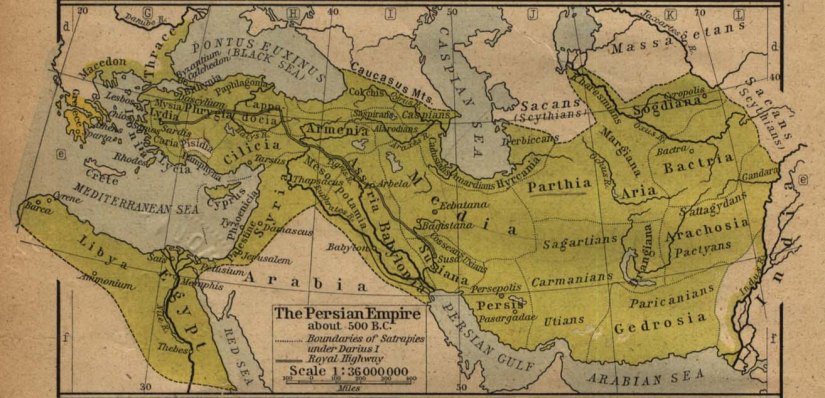
Alexandria Eschate was located 300 km north-west of the main Greek colonies in Central Asia, at Bactria.
From 250 BCE, the city likely had had greater contact with Bactria, after the Greco-Bactrian king Euthydemus I extended his control into Sogdiana.
Alexandria Eschate was also located around 400 km (249 mi) west of the Tarim Basin (now Xinjiang, China), where other Indo-European peoples, like the Khotanese, Tocharians, Wusun and/or Yuezhi were established.
There are indications that Greek expeditions traveled as far as Kashgar. The historian Strabo claims that the Greeks “extended their empire even as far as the Seres and the Phryni [possibly the Xiongnu]”. “Seres” meant either China proper – in which case the Greeks achieved the first direct contact between China and a European society, some time around 200 BCE – or the peoples of the Tarim. In any case, a city known to the Chinese as Dayuan, which was mentioned by scholars from the Han dynasty (1st century BCE to 2nd century CE), was almost certainly Alexandria Eschate. The prefix da meant “Great”, while the suffix Yuanwas the Chinese rendition of Ionians. Chinese embassies were established in Dayuan, beginning with Zhang Qian opened around 130 BCE. This contributed to the opening up the Silk Road from the 1st century BCE.
Caliphates
Khujand was conquered by the Muslim armies in the early 8th century under Qutayba ibn Muslim, and incorporated into the Umayyad and later Abbasid Caliphates. In the late 9th century, however, it reverted to local rule of Turkic governors, and eventually incorporated for a short period into the Samanid Empire.
Kara-Khanid Khanate
It came under the rule of the Kara-Khanid Khanate in 999 and after the division of Kara Khanids in 1042, it was initially part of Eastern Kara Khanids, and then later passed to the western one.
Karakhitans
Karakhitans conquered it in 1137, but it passed to Khwarazmshahs in 1211.
Mongols
In AD 1220, it strongly resisted the Mongol hordes and was thus laid to waste – around 20,000 Mongol soldiers surrounded the city and besieged it but a local man opened the doors of the city and let the Mongol army in.
In the 14th century, the city was part of the Chagatai Khanate until it was incorporated into the Timurid Dynasty’ in the late 14th century, under which it flourished greatly.
The Shaybanid dynasty of Bukhara next annexed Khojand, until it was taken over by the Kokand Khanate in 1802, however Bukhara regained it in 1842 until it was lost a few decades later to the Russia.
In 1866, as most of Central Asia was occupied by Russian Empire, the city became part of the General Governorate of Turkestan, under Tsarist Russia.
and towns such as Osh, Jalal-Abad, Karabalta, and Talas, with a possible extension into the Kyrgyz capital of Bishke
What to see in Khujand
Khujand Fortress and Historical Museum of Sughd
has around 1200 exhibitions with most being open to the public.
The remains of Alexander’s town lie in the tell of the old citadel in Khojand. Although the oldest surface remains of the walls date only to the 10th century, Soviet and Tajik excavations of the site have revealed that below the modern surface are medieval, Hellenistic and Achaemenid layers. These layers have revealed fortifications dating to around the 4th century BC.
Other remains include household utensils, armaments and building materials which are exhibited in the Museum of Regional Studies in Khojand. The site has also revealed numerous Hellenistic coins and pottery.
In the Tabula Peutingeriana, below the city there is a rhetorical question in Latin: “Hic Alexander responsum accepit: usque quo Alexander?” (English: Here Alexander accepted the answer: “Until where, Alexander?”) — referencing both his insatiable appetite for conquest and a legend from the Alexander romance in which “celestial creatures” admonished Alexander to not pursue further explorations, which would ultimately lead to his untimely death.
Alexandria Eschate is the final destination of Euxenus, son of Eutychides of the deme of Pallene, the protagonist of Alexander at the World’s End by Tom Holt.
Horses of Heaven, by Gillian Bradshaw, is set in Alexandria Eschate, c. 140 BC
Sheikh Muslihiddin Mausoleum
located on the main square across the Panjshanbe Market
Panjshanbe Market
(Бозори Панҷшанбе / Persian for “Thursday’s Market”), one of the largest covered markets in Central Asia

2 thoughts on “Khujand”