
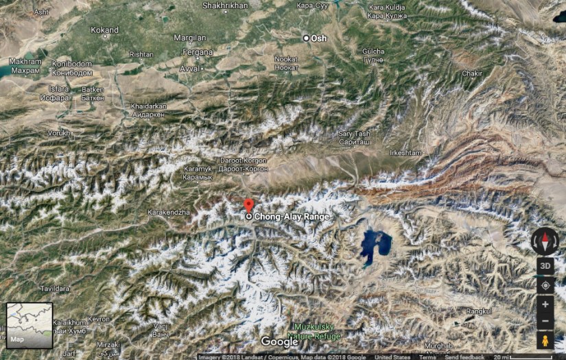
The Trans-Alay Range is the northernmost range of the Pamir Mountain System and is easily accessible from Osh.

It is located in the area where the Pamirs and the Tian Shan come together. This heavily glaciated range forms the border between Gorno-Badakshan province in Tajikistan and Osh Province, Kyrgyzstan, stretching eastwards until the border with China. To the north lies the Alay Valley and to the south, the Muksu River.
The highest peak in the range is 7,134 m high Lenin Peak. The Kyzylart and Ters-Agar mountain passes geographically divide the range into three parts: the western —highest peak Sat Peak (5,900 m), the central —with some of the highest summits, including Lenin Peak, Dzerzhinsky Peak (6717 m), Oktyabrsy Peak ( 6780 m), and Marshal Zhukov Peak (6,842 m), and the eastern — highest peak Kurumdy I summit (6,614 m)
Lenin Peak
The Trans Alay range is dominated by Lenin Peak (7134m), a popular peak for those who’re trying their first attempt of high-altitude climbing. Zaalaiski is popular among the climbers with graded routes between Russian alpine grades of 2 and 6, mostly on ice and snow. Established base camp at Achik-Tash (3700m, accessible from Osh) is popular base for the climbers. Virtually all climbers visiting the area aim for normal route of Pik Lenin.
Busiest campsite in Trans-Alay is Achik-Tash camp (3700m), located to the north of Lenin Pwak. It is accessible from the city of Osh. From Osh, it takes 8-10 hiurs. Alternatively, it can be reached by helicopter in half an hour from Osh or 2,5 hours from Tashkent.
There is a rumor of a first ascent in 1932 from the south side by Timashev and team.
But it is not sure if they were on the main summit. The original expedition report or the Soviet Root book would be needed to verify.
Trans-Alay Range Passes
The Trans-Alay is located in the area where the Pamirs and the Tian Shan come together. This heavily glaciated range forms the border between Gorno-Badakshan province in Tajikistan and Osh Province, Kyrgyzstan, stretching eastwards until the border with China. To the north lies the Alay Valley and to the south, the Muksu River
Kyzylart Pass – Gateway to Tajikistan
Sary Tash is a major crossroad, if you’re about to pass the Kyzylart Pass, it’s a good idea to spend a night there to accustom yourself to the high altitude (Sary Tash is 3170 metres above sea level).
Although this remote village has only some shop-cafes, a petrol station and five guest houses. it is an important road junction connecting China, Kyrgyzstan and Tajikistan. Its name is derived from Turkic roots and means “yellow-stone”
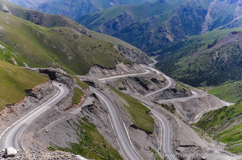
Kyzylart Pass is a mountain pass and border crossing in the Trans-Alay Range on the border of Tajikistan and Kyrgyzstan. The highest point is 4,280 m (14,042 ft). Throughout the area, the land is typically rugged and dry. It is crossed by the Pamir Highway which leads south from Sary-Tash in the Alay Valley up onto the Pamir plateau toward Karakol Lake and Murghab,Tajikistan. In the late nineteenth century the Russians used to explore and eventually occupy the Pamir plateau.
The Pamir Mountains, or the Pamirs, are at the junction of the Himalayas with the Tian Shan, Karakoram, Kunlun, Hindu Kush, Suleman and Hindu Raj ranges. They are among the world’s highest mountains.
The precise extent of the Pamir Mountains is subject to debate. They lie mostly in the Gorno-Badakhshan province of Tajikistan. To the north they join the Tian Shan mountains along the Alay Valley. To the south they border the Hindu Kush mountains along Afghanistan’s Wakhan Corridor. To the east they are generally considered to extend to the range that includes China’s Kongur Tagh,


Torugart Pass – Gateway to China
At the Torugart Pass you will be able to look east and to see China. The road that you are traveling on is the actual Silk Road. Naryn Region of Kyrgyzstan and the Xinjiang Autonomous Region of China.
The scenic Lake of Chatyr-Kul lies near the pass on the Kyrgyz side. The road to Naryn and then to Balykshy and Bishkek—stretching for some 400 km (250 mi)—is narrow and in winter often impassable due to heavy snowfall and frequent avalanches. On the Chinese side, the Torugart Port of Entry , where travelers must clear for customs, is located about 110 km (68 mi) from the pass itself in Ulugqat County of the Kizilsu Kirghiz Autonomous Prefecture. It is 165 km (103 mi) to Kashgar,


Before arriving at Tash Rabat, turn your watch back to the 15th century and explore the Tash Rabat Silk Road Caravanserai. After exploring the caravanserai rooms, you can spend the night with a local, your hosts will great you with tea and bread at their Yurt Camp. It’s possible to hire a Russian style sauna where you can wash up after all the days in the mountains.
The pass was used since antiquity. During the Han dynasty it was under the jurisdiction of a micro-state called Juandu (捐毒国). During the Tang dynasty, the region came under Tang control as part of Anxi Protectorate
Russia and China first established a port of entry at the Torugart Pass in 1881. In 1906, Russia’s Sino-Russian Transport Bank financed the construction of the road from the pass to Kashgar for 20 million rubles. In 1952, the Torugart Pass replaced the Irkeshtam Pass, which lies some 165 km (103 mi) southwest, as the primary overland link between Xinjiang and the then-Soviet Kyrgyz Republic. The pass was closed in 1969 due to the Sino-Soviet Split and reopened again in 1983. In 1995, the Torugart Port of Entry was relocated to a lower elevation (2,000m), closer to Kashgar, some 57 km (35 mi) away.
The pass is open to all nationalities but clearance requires careful arrangement of transportation.
A China-Kyrgyzstan-Uzbekistan railway going through Torugard Pass has been in the works that would connect Kashgar and the Ferghana Valley since 2012. However, the Kyrgyz section of the rail has been stalled due to financial and technical issues
Irkeshtam Pass – Old Gateway to China
Irkesthtam (Erkeshtam) is one of two border crossings between Kyrgyzstan and China, the other being the Torugart Pass which lies some 165 km (103 mi) northeast abd replaced Irkeshtam as the primary overland link between Xinjiang and the then-Soviet Kyrgyz Republic. Erkeshtam is the westernmost border crossing in China. The overland travel distance from Erekshtam to Osh is 210 km (130 mi), about 800 km (500 mi) shorter than via the Torugart Border Crossing.
It is named after a village on the Kyrgyz side of the border in southern Osh Region. The border crossing is also called Simuhana (斯姆哈纳), after the first settlement on the Chinese side of the border, but Irkeshtam is now the more common name used in both countries.
For details on how to cross the Irkeshtam Pass Border from China into Kyrgyzstan (or the other way, though some things may be different in that direction) see this post prepared by Silk Road Hitchhiker , which goes through the times which things happened.
Tosor Pass
This nearly 4000 meter pass connects Naryn in the southwest to Lake Issyk Kol and Karakol to the northeast.


It is a mountain drive to remember, you will experience wild Kyrghystan in all its glory.. The best direction to travel is from Naryn because then you get the best views. The views along the exceptionally rough gravel road are drop dead gorgeous – from wide valley vistas, to stream filled lowlands, to magnificent glacier-peaked mountains. The distance from Naryn to Torsor, the village at the end of the road, is 125 miles and may take 11 hours to traverse in weather. You may experience every kind of weather on the trip – from sun, to fog, to snow, to hail. You will cross a number of rivers and streams It truly was a superb 4×4 adventure.


Just after reaching Torsor Pass, and as you start your decent, you will marvelous glaciers and their pools right next to the road. You will pass onlya few cars, bicyclists and hikers. And you will pass lots of animal herds around the valleys – cattle, horse, sheep, goats and even a large herd of yaks.
It was was not really easy but not so bad in a four wheel drive vehicle. Watch out for if the weather gets bad. You are really exposed to the elements up there. Some people do it on bikes which must be amazing!
Lake Tulpar-Kol
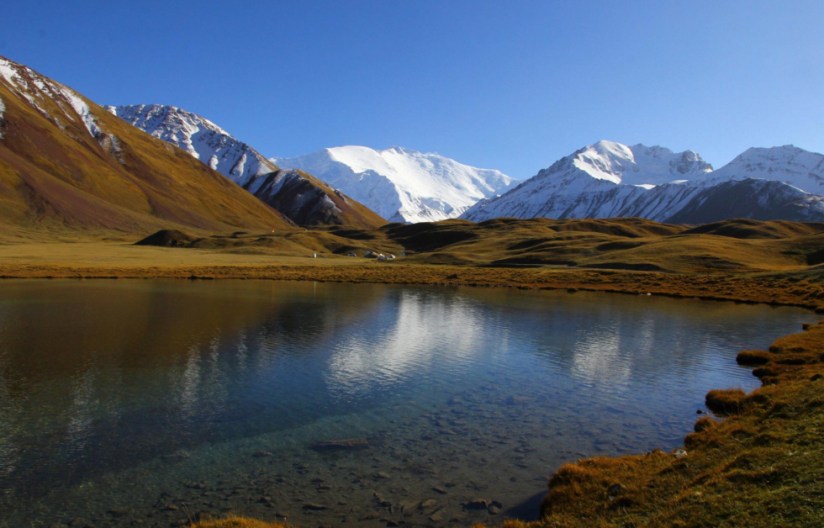
Lake Tulpar Kok is an amazing lake, a short distance from Sary Mogul with the best view of Lenin Peak – especially early in the morning, since later the weather can be really unpredictable. It is a beautiful place, thePamir mountains are so colorful, purple rocks, marmots (or other similar cute creatures).
It is easy to go for treks from the lake to the view point which is in the front of Peak Lenin. Path is visible and easy. Thre are several trekking options with beautiful vies (not all hardcore.) You can start in the morning and at the end of the afternoon transfer back to the village. Ask in Peak Lenin Guesthouse for transfer to the lake.
If you go in peak summer season, you may see horse games and you will see many yurts! Lenin Peak at 7000 m at and to spend a few nights next to yothis lake!
There are two more authentic, friendly alternatives to the more standard touristic oriented CBT yurt camp. ou can also put up your own tent.
One good option for accommodation in the village we recommend Sunny Side Guest house. Accommodation is basic, , but family is really helpful. They will put fire for you, so it will be warm and cosy. Showerwill be in another small building, but they will put the fire also there, so it will be nice and toasty. It is near the main road between two gas station and is visible from the main road. In application “maps.me” it is marked as Lenin Peak Guest house.


Kurumdy Mountain
Since territorial changes 2011 , Kurumdy Mountain Is a is the three state summit between Kyrgyzstan, Tajikistan and China. located in the Pamir Mountains in the eastern section of the Transalai Range, 22 km east of the Kyzyl-Art Pass. Kurumdy (Kurumdy I summit) has an elevation of 6,614 metres above sea level. The East Kyzilsy Glacier flows on the northern side with a length of 3,7 km and an area of 69,4 km². The Kurumdy Glacier with 17,2 km and 60,6 km² is located on the south side and flows to the west.
Due to the difficulties it is very seldom attempted and has only few ascents
The closest place to stay and to get basic supplies is Sari Tash – don’t expect too much but a perfect view over a wide green meadow with an amazing mountain range behind it. Lots of cyclists are stopping here. Sari Mogul is not far but more useful if your target is Lenin Peak or a peak in the western Transalai Range
The 1932 ascent by E. Timashev and party from south was to Kurumdy West, not the main summit. They might have been on the south ridge of Kurumdy West at Point 6154m as stated by the historican Jozef Hala. The Kurumdy I summit waas reach for the time in 2001 by Michael Mihajlov and Vitaliy Akimov by climbing a major north ridge.
The first traverse (East-West, 15 days) was accomplished in summer 2015 by the Austrians Markus Gschwendt and Katharina Pfnaisl. This was the second ascent of the main summit (6614 m, 5 August 2015). Further they traversed some 6000 m peaks of which at least two peaks were unclimbed at this time. For the ascent they used a very steep slope east oft the Kurumdy east summits (6384 m, Peak Kathi 6259 m). The descent was done by crossing the west summits (6554 m, 6283 m) and then following a north ridge to Golova Orla 5440 m from where they reached the Basecamp (3770 m)
A border-area-permit is necessary to enter this area, Approach from the north, you can take a taxi from Osh to Sari Tash, with horses to the basecamp on the northern side of the East Kyzilsy Glacier at 3770 m. Water quality can be a problem. Bring a water filter system.
There is no easy line to the summit. Success depends much on snow conditions and weather.
Learn More
Gora Kurumdy Acsent – Summit Post. Org
Mountain Climbing in the Pamir Range – Ari’s Base Camp
Crossing the Irkeshtam Pass Border (a step by step account) – Silk Road Hitchhikers

1 thought on “Trans-Alay Range”