
Kazakhstan is a vast landlocked country, larger than all of western Europe and sharing borders with Russia, China, Kyrgyzstan, Uzbekistan and Turkmenistan It is economic power house of Central Asia generating 60% of the region’s economy. You might arrive for your trip to the Silk Road in the capital Almaty. It is a short drive from Almaty to Bishkek, the capital of Kyrgystan.
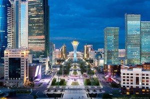
Almaty was the historic captial of Kazakhstan, and most of the silk road sites are in the south of the country. In the 1990’s the Kazakh government decided to develop the northern part of the country by building a new capital called Astana.

Kazakhstan is considered to be part of Europe and Kyrgyzstan is considered to be part of Asia and both are at the center of the Silk Road between East and West. Kazakhstan is part of the European Zone in FIFA World Cup, while Kyrgyzstan and the rest of the Silk Road Countries are in Asia Zone. Kazakhstan is the world’s largest landlocked country, and the ninth largest in the world
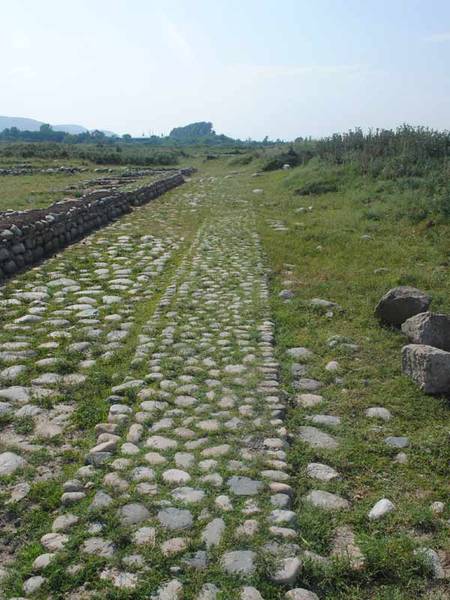
The Silk Road start in Kazakhstan at the China border. Merchants of Celestial Empire carried silk, weapons, medicines, rice, exotic goods such as tusks across Kazakh steppes to the West, to Europe. Steppe governors offered their services of safety provision for trade caravans; in exchange they demanded a share of the goods or cash. That was how quitrents or taxes and customs duties emerged.
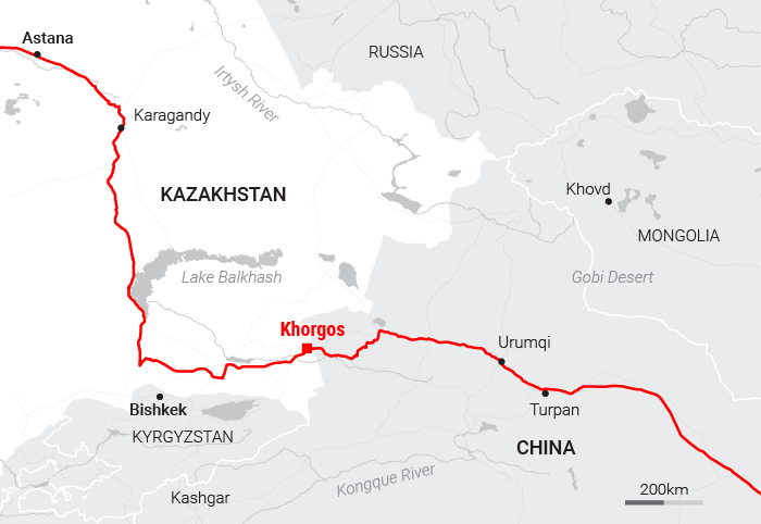
Belt and Road Initiative Khorgos: the biggest dry port in the world – South China Morning Post
Kazakhstan on the Silk Road
The main line of the Silk Road on the territory of Kazakhstan lay across the country’s south; from the border with China trade caravans moved through the cities of Talgar, Sayram/Ispidzhab, Yassy, Otrar, Taraz and further to Central Asia, Persia, to the Caucasus and from there to Europe.
There are four main Silk Road routes on the territory of Kazakhstan, each represented and marked by monuments of history and culture ) and each adopted to its envirnoment. The Silk Road brought a unification of diversity across regions with the help of universal system of exchange of human values which was created, developed and maintained by people of different ethnical, linguistic, religious belonging during more than two thousand of years of existence.
Route 1. Semirechye
Semirechye also known as Zhetysu (Semirechye) includes a diversity of climate zones including wormwood-steppe, cereal-steppe, motely grass-steppe, forest or meadow and high-altitude .

The route led from west to east from Shasha (Tashkent) to Turbat, then to Ispidzhab (Sayram after the Mongols), then the road lead east direction – to Taraz, and Dzhamukat, and on to Kulan ( Chinese Tszjuj-lan’), then to the East and the cities Mirki and Aspara after which it lead to Issukkul kettle . From Issykkul kettle through the Santash Pass and Karkary River valley the road run through the Ili Valley, through Usek and Khorgos, lead to Almalyk.
It was possible to reach the Ili Valley by another way – it stretched out from Kulan, Aspara to the towns of middle and lower reaches of the Chu River, from where the road lead to north slope of Chuili Mountains and went down to the north Pribalkhashye; or went through Chu, down and lead to the towns on the north slopes of Karatau.
Through the Ili Valley the Silk Road went though small towns, located where Kastek, Kaskelen and Almaty are today and reached Talgar. In Talgar the Silk Road forked to south and north. Through Issyk Kul, Turgen, Chilik, the south road lead to Ili Pass – through Khorgos to Almalyk.
The North Road went from Talkhiza went along the Talgar River to the Ili Pass, which located under the Kapchagay reservoir behind the Kapchaagay dam on the Ili River today. After Ili the road lead to Chingeldy, then through the Altyn-Emel Pass down to the Koksu Valley and reached Iki-Oguz (Equius), located at the place of present Kirovskoye village. Today, Altyn Emel is a National Park, founded in 1996 and covering 5,200 square kilometres, stretches along the northeastern side of the Карshagay Reservoir and the north bank of the Ili River before it flows into the reservoir.
From Iki-Oguz the road lead to Kayalyk (Koylak) – capital of Karluk dzhabgu. Further the road went to Tentek Valley, and passing Ala Kol Lake, went through the Dzhungar Gates and came to the Shikho Valley.
Route 2. Syrdarya
In western direction from Ispidzhab caravan road lead to Arsubaniket on the Arys River, to Otrar (Farab), and then down Syrdarya– in Priaralye. including the towns of s, Yassy (Turkestan), Shavgar, Sauran, Sygnak, Dzhetyasar oasis, Dzhent, Jankent (Dzhankent), and Khuvara. From Jankent the road went to north-eastern side, came to the banks of Beleuty River and lead to Kounrada, Karasakpay region.
Route 3. Saryarka
Saryarka part laid on the territory of the “Great Steppe” of the Central Kazakhstan – Desht-I Kypchak. Monuments of this region bent for many small rivers, Ulytau foothills, banks of the Ishim, Nura, Sarysu, and Irtysh Rivers
Sarysu Path lead to the Central Kazakhstan: from Otrar through Shavgar and the Turgay Pass on Aksumbe, it went to the lower Sarysu River and up along the river to Ulytau, and from there to Ishim along the Irtysh. The shorter path went through Suzak to the Lower reaches of the Chu River, and from there – through the Betpak-Dala Desert – to Dzhezkazgan region in Central Kazahkstan.
One more road “Khanzhol” was used till present time: it was from Taraz down along Talas through Muyunkum and the Betpak-Dala Desert sands to the banks of the Atasu River. According to descriptions from Tamim ibn Bakhra and al-Idrisi, there was a trade path to Kimaks in Irtysh from Taraz through Adakhkes and Dekh Nujikes . I
The Ili Valley connected with the Central Kazakhstan by the road which went along north slopes of Chu-Ilii Mountains, then along the Chu River in its lower reaches to the Sarysu banks, which the northern Ili Route above also followed.
From northern Ili road, which lead to Djungar gates, there was a direction, rounded Alakol from western side and through Tarbagatay lead to Irtysh – to the land of kimaks state with the Bandzhar, Khanaush, Astur, Sisan and “capital” of Khakan. On the Ishim River these roads lead to Bozok and hen to the north and west.
Route 4. Mangyshlak (Uralo-Prikaspiyskiy).
The Mangyshlak (Uralo-Prikaspiyskiy) route of the Silk Road, located along eastern bank of the Caspian sea, situated in essential natural landscape of deserts and semi-deserts, differentiated by wide diversity of its natural complex and extremal climatic and natural conditions.
Population of these regions was a conglomerate of nomad and cattle-breeding tribes, who controlled trade roads, adjusted to the system of wells, springs, small rivers,
It was possible to reach lower Ural and Volga from Urgench, following the road of Ustyurt caravanserais. Kyzylkala was located on this part of the road. Passing by the territories of Southern and Northern Priaralye the trade arteries lead to the towns on the Ural (Zhaiyk) River: Saraichik and Zhaiyk . Then they lead the caravans west to Europe, Crimea and Caucasus, and also to the “Zhaiyk Road” to the Esatern Priuralye, Ural and Povolzhye.
Directions of the Silk Road were not static: during the centuries the biggest significancy received first one then another parts and nets; some of them died out totally, and towns and trade stations came to default.
We can define period of intensive functioning of the parts of the Silk Road stated above. In VI-VIII the main line was Syria – Iran – Central Asia – Southern Kazakhstan – Talass valley – Chu valley – Issykkul kettle – Eastern Turkestan. Branch of this road lead to the mentioned above line from Byzantine through Derbent in Prikapispiyskiy steppe, and Mangyshlak, in Priaralye, in Southern Kazakhstan (in Sasanid Iran, after concluding trade-diplomatic union between Western-turk kaganat and Byzantine). In IX-XII this route was used with less intension, but in XIII-XVI it started to function again (in connection with the appearance of Mongol Empire).
Kazakhstan History
Kurgans
Although little is known of the lives of the nomadic tribes, who 2,500 years ago roamed the Asian steppe land in today’s Kazakhstan, the region’s semi-arid climate has provided the perfect temperature and humidity in the ground’s permafrost for the preservation of rare organic artifacts. Richly woven textiles, gorgeous gold-leaf covered wooden horse tack ornaments and other rare organic artifacts, normally not preserved in other areas of the Ancient Near East and Central Asia, have been excavated in burial mounds, or “kurgans”—some more than 100 feet in diameter—that uniformly dot the Kazakhstan landscape,
Since the ground’s pervasive layer of permafrost keeps the organic contents of a kurgan at a constant temperature, preventing decay, researchers must take extreme measures to protect artifacts during excavation. Oftentimes, entire sections of the excavated site are packaged and removed from the ground intact. The tomb is then transported to a climate-controlled laboratory where researchers carefully examine the kurgan’s contents.
Since the tribes moved about the countryside with each change of the season, few physical evidences or traces remain of the culture. No centralized city centers or trade routes have found or documented. Instead to understand how the nomads lived and died, archeologists mainly rely on the kurgans, where elite members of the society were interred with their goods and even with their horses.
Saka People
What is beginning to emerge from the excavations is the evidence of a highly sophisticated culture, one that maintained communication networks and strategic migratory routes. But also evidenced is the fact that the Saka people, as the nomadic tribes were called in ancient Persian sources, had a close, almost sacred bond, with their horses. Not an entirely surprising fact, since nomadic cultures throughout the millennia have depended on domesticated animals for both transportation and food. But archeological evidence uncovered from Saka burial mounds indicates that horses were treated as divine beings.
In one unearthed kurgan, a man was interred with a woman—who was presumed to be his mother—in a large sarcophagus, surrounded by 13 horses that were sacrificed for the burial. Three of the horses were decorated to resembled supernatural creatures, and wearing leather masks with wooden horns painstakingly decorated with gold leaf
In life, horses were outfitted with saddles and bridles as extravagantly decorated with ornate gold-laden garb similar to the rich costumes of their riders, often Saka nobility. As for the nobles, gold ornaments were sewn into intricately woven textiles and diadems, golden headbands signifying royal descent, graced the heads of the richest tribe members. Metal shaping tools were used to form incredibly minute and precise details on the golden ornaments, and semi-precious stones such as carnelian and turquoise were carefully applied as accents.
The craftsmanship was appreciated far beyond the borders of today’s Kazakhstan. Carvings sculpted into the palace walls of ancient Persia depict the arrival of foreign Saka delegations to present Persian kings with trade items. On the façade of the Apadana, a fifth century building at Persepolis in southwestern Iran, a carving depicts a procession of Saka people bringing jewelry and other ornaments as tributary to the Persian King.
Horse tack ornaments and jewelry carved from Kazakh trees has surfaced in many archeological finds spanning many territories in Eurasia, suggesting that the Saka people were heavily integrated in the ancient trade network.
Yet as much as researchers can glean from the physical remnants of the ancient nomads, much about their way of life is still shrouded in mystery. Local Kazakh animals, such as red deer, snow leopards, wolves, ravens, ibexes and Bactrian camels are frequently seen in jewelry and small altars made of stone or bronze. In some depictions, snow leopards were given wings, suggesting they might have been deified just as the horned horses were. The ibex appears again and again in ancient artifacts and still today remains a symbol of supernatural power in Kazakhstan.
Berel Burial Grounds
x

More than 150 artifacts and works of art excavated from these sites were displayed in a 2012 Smithsonian exhibition “Nomads and Networks: The Ancient Art and Culture of Kazakhstan,” The works represented some of the most significant archaeological discoveries made in Kazakhstan over the past few decades, and it was the first show of ancient visual arts of Kazakh culture in North America.
These cities emerged because merchants traveling across the enormous Kazakh steppes made stops which turned into caravanserais and those in turn grew into settlements which further became cities.
The main route of the Silk Road in the region went across Semirechye and South Kazakhstan. This route started in the second half of the 6th century when Semirechye and South Kazakhstan became parts of Turkic Khaganate, the huge nomadic empire stretching from Korea to the Black Sea. In the late 6th century the Khaganate broke up into Eastern Turkic and Western Turkic ones. Semirechye became the center of Western Turkic khaganate with the capital in the city of Suyab. A variety of new cities emerged in Semirechye, and in the south of Kazakhstan the cities which were built on the Silk Road or were connected with it by trade relations grew the most. The largest of them were Suyab, Taraz and Ispidzhab.
The Silk Road across Semirechye and South Kazakhstan functioned until the 14th century when the civil strife and wars destroyed the city. Its last revival occurred in the middle of the 13th century when the route was used by trade and diplomatic embassies moving to Korakorum, the capital of Mongolian Empire.
Learn More
Kazakhstan on the Silk Road – Avantour
Burial Mounds Preserve Culture of Ancient Nomads in Kazakhstan – Smithsonian.com

6 thoughts on “Kazakhstan”