Jalal-Abad Region s surrounded by (clockwise from the north) Talas Region, Chuy Region, Naryn Region, Osh Region, and Uzbekistan. The southern edge of the region is part of the Fergana Valley. The rest of the region is mountainous.
M41, the main north-south highway from Bishkek to Osh, takes a very crooked route down the center of the region. Another road follows the south border almost to the western tip and then turns northeast up the Chatkal valley to Kyzyl-Adyr in Talas Region. Another road (closed in winter and requiring a jeep) runs east to Kazarman and Naryn and crosses the Fergana range . An ancient inn called Tash Rabat is near the top of this pass and served travelers on the Silk Road
The ancient city of Jalal-Abad is at the north-eastern end of the Fergana Valley along the Kögart River valley, in the foothills of the Babash Ata mountains, very close to the Uzbekistan border.
Except for the small fringes of the Fergana Valley, Jalal-Abad Region is a land of mountains. There are unlimited trekking possibilities in the area, but the lack of infrastructure, except at Arslanbob, poses access problems to visitors.
A biodiversity conservation program supported by the government and the Global Environment Facility (GEF) is working to protect these natural resources and promote eco tourism. (See our page Jalal-Abad Adventure for details)
Jala-Abad on the Silk Road
One of Kyrgyzstan’s main branches of the Silk Road passed through Jalal-Abad and the region and has played host to travelers for thousands of years, archaeological remains are visible today in some of the more remote parts of the region – such as Saimalu Tash and the Chatkal Valley. These have included travelers, traders, tourists and pilgrims (to the various holy sights) and sick people visiting the curative spas such as in the Ayub Tau mountain, at the altitude of 700 m above sea level some three kilometers out of town.
There is a legend that the water from the Azreti-Ayup-Paygambar (the Prophet Job) spa cured lepers. According to the legend there was a grave, a mosque and the khan’s palace near the spa.
Jalal-Abad
-abad is a Persian suffix often used in city names in Persianate societies to refer to the person who founded the community. It is said that Jalalabat was named after Jalal ad Din, who was renowned for setting up Caravanserais to serve travelers and many pilgrims who came to the holy mountain.
In early 19th century a small Kokand fortress was built, and a small kishlak grew up nearby. The local people were engaged in agriculture, trade and provided services to the pilgrims visiting the spas. In the 1870s, Russian migrants came to the region. They set up a garrison town and military hospital.
Shah-Fazil Archaeological Complex

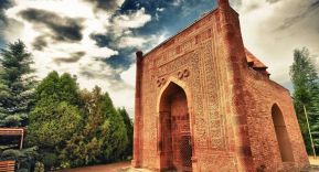
Shah Fazil Mausoleum
The Shah Fazil Mausoleum Archaeological Complex is about 8 km away from Ala-Buka, in western Jalal-Abad region, 200 km and about three and half hours by car from Jalal-Abad. The Shah-Fazil Masueleum is one of the only exfrom the Karakanid epoch (See my post for more details) This major historical and architectural complex of Central Asian combines monuments of different eras.
Formerly the valley was a trade route from the Fergana Valley northward and had a fairly dense population, but trade declined after the 12th century. There are burial mounds from the first and second millenia BC.century.
The road continues west past Terek-Say and over the west end of the Chatkal Range, then north and northeast up the Chatkal Valley. To the west of the bend is the Besh-Aral State Reserve at the far west end of Jalal-Abad Region. Chatkal National Park in Uzbekistan is across the border.
To the northeast of the bend is Yangi-Bazar with the mausoleum of Idris Paygambar, an Arab mystic. The road goes up the Chatkal Valley over the 3302m Kara-Bura Pass (closed in winter) to Kyzyl-Adyr in Talas Region. There is no public transport.
The complex includes the sacred mountain Archa- Mazar and monuments from the Bronze Age of the 18th and 19th century BCE. It later included the Holy Hermit Cave and several other mausoleums, including the Mausoleum of Hoxha Alamdara of the 19th century, the mausoleum of 2700 warriors (shahids) of Islam,and the mausoleum of Safid- Bulan. A characteristic feature of these sites is the combination of austerity and luxury decoration, presented in the form of carvings of blue, yellow and red colors.
The complex also includes the Kyrgyz mosque, the grave of Martyrs, Mazarsky settlement (VIII-XII centuries), the Zharak-tepe barrow, the 19th century mosque, “Sacred Stone”, pond-house,
Up to the mid-20th century, religious festivals and the sacrificing of animals were allowed to be held at the complex. Today, it is still considered as a holy place as pilgrims from Central Asia travel to pray for healing and blessing.
Safed-Bulan
The Shah Fazil Mausoleum Archaeological Complex is located near the village of Safed-Bulan. The settlement is at least one thousand years old and is mentioned in medieval, Arabic and Persian scriptures under the name Isbid Bulan.
Safed-Bulan is named after Bulan (woman), a black African maiden. According to legend, Bulan came to the lands of Central Asia with the army of Arabic warriors led by her beloved and, perhaps, her master –Shah-Jarir (grandson of Prophet Mohammad).
Historical sources tell that the local tribal inhabitants “pretended to accept” a new religion of Islam. According to the legend, the locals attacked while the Arabs had laid down their weapons for their Friday prayers. While some warriors were able to flee, many defenseless Arabs were beheaded on the spot.
Bulan unsuccessfully searched for her lover who, it is believed, had fled back to Arabia. Though everyone was prohibited from burying the dead, Bulan gathered the 2700 heads of the decapitated Arabs, washed them of blood in the river and buried them all.
She was blessed for her deed by becoming completely white all over. Hence the name: Safed (or safid) Bulan (or Bulon) (White Woman). Some historians believe that Safed Bulan’s hair turned white due to the shock she had experienced witnessing the massacre.
When Safed Bulan died, she was buried near the slain Arab warriors. Her grave became a place of pilgrimage, or a mazar ( Arabic for holy mausoleum). Kirin mechet, the place where the warriors were beheaded, stands nearby on the left. According to the legend, the rock that stands at the mazar’s entry marks the exact spot where Safed Bulan washed the heads of the warriors.
Women visit the mausoleum to pray and ask for Safed-Bulan’s blessings. Those who have a hard time conceiving children visit in order to touch the “fertility rock” that lies in the small yard of the mausoleum
Shah-Fazil Mausoleum
The most significant mausoleum is of Shah Fazil, built between 1050 and 1060. It is a rare architectural jewel. The four walls are all of equal length and the interior richly decorated with ganch carving.
It is a square building, height of which 11 metres. The interior of the mausoleum is decorated with ganch carvings. The legend says that there was an attack on defenseless people, in which 2700 soldiers were killed. Local girl Bulan washed decapitated heads in order to find the head of her beloved. According to excavations of scientists, ruler of Fergana Mahmud ibn Nasir, known as Shah Fazil was buried here, in his honor the mausoleum Shah Fazil was built here.
There is a story about a African maiden who came into the area with her husband and the Arab warriors led by Shah-Dzharir. One day during a intense praying session, a group of locals attacked guest sand beheaded most of them on the spot, only a few survived. Then she buried all the heads of the Arab warriors. For her actions, she was blessed. Later when she died, the river she washed the heads in, became a place of pilgrimage for people. The womens, would go and pray for that they can give birth to children.
In 2003 the building of the mausoleum was renovated. Nowadays, Shah Fazil mausoleum is not only a great scientific and historical value but a place of regular pilgrimage.
Arslanbob
Arslanbob (Kyrgyz: Арстанбаб) is a village, sub district, valley, mountain range, and a large wild walnut (Juglans regia) forest in the Jalal-Abad Region of Kyrgyzstan. Kyrgyzstan’s first known export to Europe was the Arslanbob walnut. Two waterfalls are located in the area which attract tourists, pilgrims and other visitors during the spring and summer months.
Even though Arslanbob is located in Kyrgyzstan, the residents here are predominantly Uzbek people, you’ll find a different culture in this little village than you would in the rest of the country.
Arslanbob on the Silk Road
Arslanbob is a magical mountain village and is named after an 11th-century figure, Arslanbob-Ata. He may have been of Arab descent as in that language, Aslan translates to “lion” and bab to “gate”, while in Turkic languages, ata means “father of”. ergo “father of the lion gate”. ‘Bob’, used as a suffix, denoting “a traveler and explorer” Arslanbob is a place for travelers and explorers.
The walnut Juglans regia is native to a wide region in Central Asia. By the time of Alexander the Great, the walnut forest was locally known for hunting. He took the walnuts from Sogdiana, and these formed the European plantations. It is also said that he exported the walnut plants to Greece during his campaigns in Central Asia. This is inferred from the usage of the word “Gretski”, meaning “Greek” nuts for walnuts in Russian. Hence, it is nicknamed as the ″Greek nut″
Arslanbob Walnut Forest
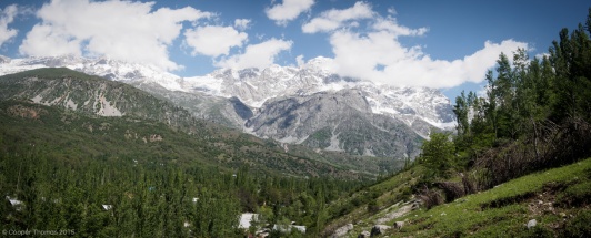
What really sets Arslanbob apart is its natural surroundings. If you like to walk, but not necessarily go on any backbreaking treks, you can hike alongside the river, and up to the Panorama Viewpoint. This is a great spot to relax with a book and enjoy the breathtaking views. Another option is to go fishing with a local fisherman. Spend the night under the stars in a tent, while fishing in the evening and early morning. Regardless of whether or not you catch anything, just being out in nature, alongside a beautiful river with the locals is a memory you’ll never forget.
If you’re feeling adventurous, you can opt for the overnight trek (about 15 miles) which heads out past the Big Waterfall, through the Halfsummers Pastures and the Walnut Grove, before returning back to the village.
Guides can be hired for this route, and although 15 miles may not sound all that strenuous for a two-day hike, the elevation gain is around 4,450 feet.
The walnut forest preserve is is the largest walnut grove on Earth, 11,000 hectares (27,000 acres), between the Fergana and Chatkal Mountains at altitudes between 1,500 and 2,0000 metres (4,900 6,600 ft) on the Fergana range’s south-facing slopes.
Arslanbob’s grove produces 1500 tonnes of walnuts per year and is the largest single natural source of walnuts on Earth. It is considered a treasure of the southern forests of Kyrgyzstan as the trees have a life span of about 1000 years and yield large amount of fruits known for its medicinal qualities. It is a popular wood for making furniture and other crafts.
During the months of September to November, local families camp out in the forest in order to harvest as many walnuts as they can during this important season. The families earn $3 for every 6.5 pounds of nuts collected.
World Conservation Union (IUCN) held a workshop in September 1995 at Arslanbob to specifically discuss “an exceptional botanical garden” of walnut fruit trees found in Kyrgyzstan distributed over the two large forest ranges of Arslanbob Kugart and Khoja Ata running east west, which in the past covered an area of 630,900 hectares (1,559,000 acres). However, over the decades of exploitation, the area under walnut trees was reduced.
Various wild forms of other fruit-bearing species including apple (Malus siversiana), pear (Pyrus korshinsky), and plum (Prunus sogdiana).
Waterfalls
Behind the town of Arslanbob are the Khrebet Babash-Ata Mountains. There are two waterfalls nearby. One measures 80 metres (260 ft) high and has a slippery scree slope; it is situated in a cliff face north of the village. Another, to the east, is 23 metres (75 ft) in height and has two prayer caves, one of which is known as the Cave of the 40 Angels.Within walking distance is the Dashman Forest Reserve, another walnut forest.
Heading east from town will bring you to the small, 65 foot high waterfall, while heading north, you’ll arrive at the big, 290 foot waterfall! During the off-season, you’ll have the falls practically to yourself.
Saimalu Tash
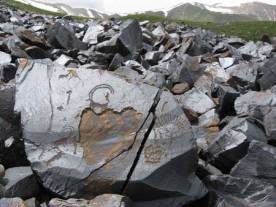
Saimaluu Tash (meaning ’embroidered’ or ‘patterned stones’ in Kyrgyz) is a petroglyph site in northern Jalal-Abad Province, , south of Kazarman. The road southwest to Jalal-Abad city normally requires a 4×4 as far as the Kaldama Pass over the Ferghana range. Once over the pass the country opens out to the Ferghana Valley. The road east through Baetov and Dostuk to Naryn is somewhat better
Over 10,000 carved pictures, which are black-and-white rock paintings, have so far been identified, making the site a globally important collection of rock art. They are a sacred display of offerings of the ancient people of the lower valley.
The site was proposed for listing under the UNESCO List of World Heritage Sites by the Kyrgyz National Commission for UNESCO on 29 January 2001. It is listed under the UNESCO’s Tentative List as “Saimaly-Tash Petroglyphs” for inscription under Cultural Category under Criteria: (iii), (iv) and (vi)
Learn More
The Long and Winding Road to Arslanbob– Cooper Thomas
Arslanbob: Kyrgyzstan’s Magical Mountain Village – Travel Pulse
Don’t Miss Out on These Hikes With Breathtaking Views – Travel Pulse
We need a map for those who want to explore the natural beauty of Arlansbob
x












1 thought on “Jalal-Abad Region”